You are here: Home > Network List > TA - USArray Transportable Network (new EarthScope stations) Stations List
> Station C19A Slack Wire Ranch, Winifred, MT, USA > Earthquake Result Viewer
C19A Slack Wire Ranch, Winifred, MT, USA - Earthquake Result Viewer

| Earthquake location: |
Kermadec Islands Region |
| Earthquake latitude/longitude: |
-27.4/-176.3 |
| Earthquake time(UTC): |
2009/02/18 (049) 21:53:45 GMT |
| Earthquake Depth: |
25 km |
| Earthquake Magnitude: |
6.8 MB, 7.2 MS, 6.9 MW, 6.9 MW |
| Earthquake Catalog/Contributor: |
WHDF/NEIC |
|
| Network: |
TA USArray Transportable Network (new EarthScope stations) |
| Station: |
C19A Slack Wire Ranch, Winifred, MT, USA |
| Lat/Lon: |
47.73 N/109.05 W |
| Elevation: |
966 m |
|
| Distance: |
96.1 deg |
| Az: |
38.771 deg |
| Baz: |
235.546 deg |
| Ray Param: |
0.04059739 |
| Estimated Moho Depth: |
17.75 km |
| Estimated Crust Vp/Vs: |
1.60 |
| Assumed Crust Vp: |
6.518 km/s |
| Estimated Crust Vs: |
4.074 km/s |
| Estimated Crust Poisson's Ratio: |
0.18 |
|
| Radial Match: |
94.44948 % |
| Radial Bump: |
347 |
| Transverse Match: |
81.84819 % |
| Transverse Bump: |
400 |
| SOD ConfigId: |
2658 |
| Insert Time: |
2010-03-06 11:42:50.485 +0000 |
| GWidth: |
2.5 |
| Max Bumps: |
400 |
| Tol: |
0.001 |
|
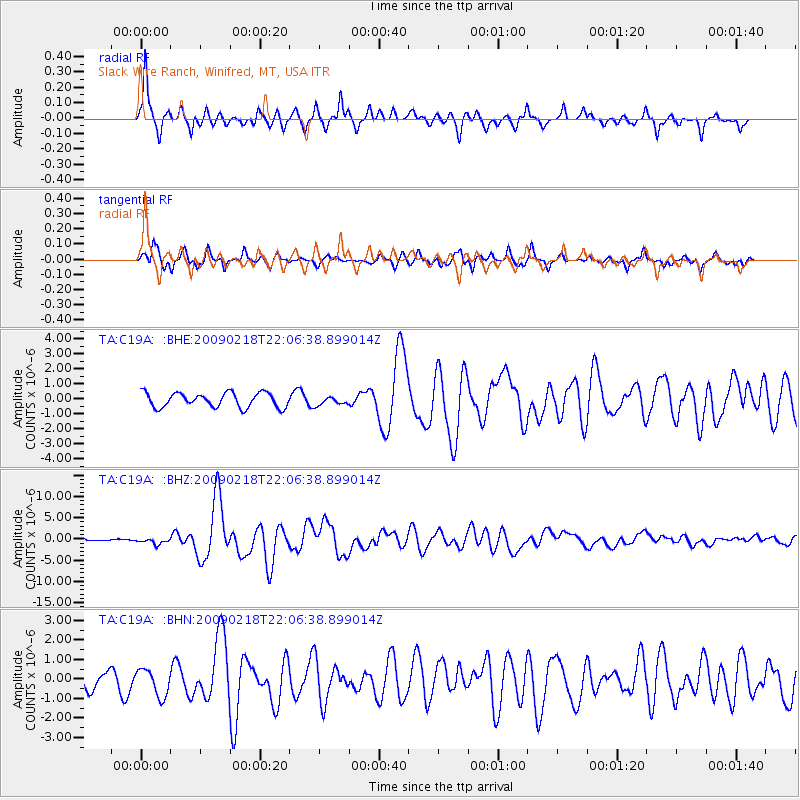
Signal To Noise
| Channel | StoN | STA | LTA |
| TA:C19A: :BHZ:20090218T22:06:38.899014Z | 2.3526862 | 7.0078534E-7 | 2.9786605E-7 |
| TA:C19A: :BHN:20090218T22:06:38.899014Z | 1.5486611 | 6.969966E-7 | 4.50064E-7 |
| TA:C19A: :BHE:20090218T22:06:38.899014Z | 0.5620132 | 2.7319695E-7 | 4.861041E-7 |
| Arrivals |
| Ps | 1.7 SECOND |
| PpPs | 6.9 SECOND |
| PsPs/PpSs | 8.6 SECOND |


