You are here: Home > Network List > CN - Canadian National Seismograph Network Stations List
> Station INK INUVIK, NT > Earthquake Result Viewer
INK INUVIK, NT - Earthquake Result Viewer
*The percent match for this event was below the threshold and hence no stack was calculated.
| Earthquake location: |
Near S. Coast Of Western Honshu |
| Earthquake latitude/longitude: |
34.8/135.6 |
| Earthquake time(UTC): |
2018/06/17 (168) 22:58:35 GMT |
| Earthquake Depth: |
11 km |
| Earthquake Magnitude: |
5.5 Mww |
| Earthquake Catalog/Contributor: |
NEIC PDE/us |
|
| Network: |
CN Canadian National Seismograph Network |
| Station: |
INK INUVIK, NT |
| Lat/Lon: |
68.31 N/133.53 W |
| Elevation: |
44 m |
|
| Distance: |
58.5 deg |
| Az: |
25.863 deg |
| Baz: |
285.162 deg |
| Ray Param: |
$rayparam |
*The percent match for this event was below the threshold and hence was not used in the summary stack. |
|
| Radial Match: |
58.720074 % |
| Radial Bump: |
400 |
| Transverse Match: |
80.137314 % |
| Transverse Bump: |
400 |
| SOD ConfigId: |
13570011 |
| Insert Time: |
2019-04-30 09:36:01.494 +0000 |
| GWidth: |
2.5 |
| Max Bumps: |
400 |
| Tol: |
0.001 |
|
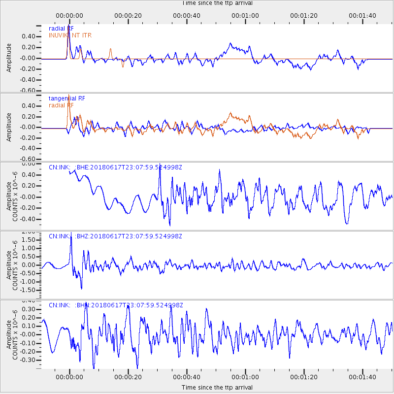
Signal To Noise
| Channel | StoN | STA | LTA |
| CN:INK: :BHZ:20180617T23:07:59.524998Z | 7.7234244 | 7.278158E-7 | 9.423486E-8 |
| CN:INK: :BHN:20180617T23:07:59.524998Z | 1.0609761 | 1.2355663E-7 | 1.1645562E-7 |
| CN:INK: :BHE:20180617T23:07:59.524998Z | 1.23491 | 2.8897375E-7 | 2.3400389E-7 |
| Arrivals |
| Ps | |
| PpPs | |
| PsPs/PpSs | |


