You are here: Home > Network List > TA - USArray Transportable Network (new EarthScope stations) Stations List
> Station C19A Slack Wire Ranch, Winifred, MT, USA > Earthquake Result Viewer
C19A Slack Wire Ranch, Winifred, MT, USA - Earthquake Result Viewer
| Earthquake location: |
Kuril Islands |
| Earthquake latitude/longitude: |
46.0/151.4 |
| Earthquake time(UTC): |
2009/04/18 (108) 19:17:58 GMT |
| Earthquake Depth: |
35 km |
| Earthquake Magnitude: |
6.3 MB, 6.3 MS, 6.6 MW, 6.4 MW |
| Earthquake Catalog/Contributor: |
WHDF/NEIC |
|
| Network: |
TA USArray Transportable Network (new EarthScope stations) |
| Station: |
C19A Slack Wire Ranch, Winifred, MT, USA |
| Lat/Lon: |
47.73 N/109.05 W |
| Elevation: |
966 m |
|
| Distance: |
63.2 deg |
| Az: |
48.247 deg |
| Baz: |
309.632 deg |
| Ray Param: |
0.059689492 |
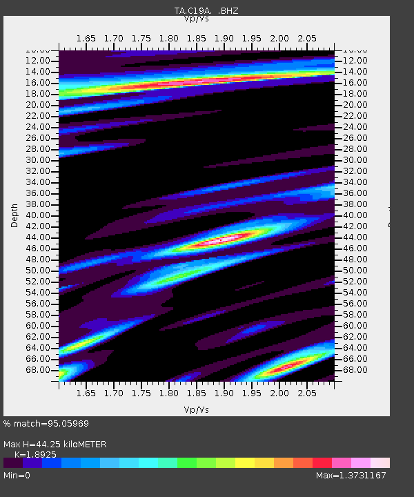
| Estimated Moho Depth: |
44.25 km |
| Estimated Crust Vp/Vs: |
1.89 |
| Assumed Crust Vp: |
6.518 km/s |
| Estimated Crust Vs: |
3.444 km/s |
| Estimated Crust Poisson's Ratio: |
0.31 |
|
| Radial Match: |
95.05969 % |
| Radial Bump: |
400 |
| Transverse Match: |
89.96905 % |
| Transverse Bump: |
400 |
| SOD ConfigId: |
2658 |
| Insert Time: |
2010-03-06 11:43:02.528 +0000 |
| GWidth: |
2.5 |
| Max Bumps: |
400 |
| Tol: |
0.001 |
|

Signal To Noise
| Channel | StoN | STA | LTA |
| TA:C19A: :BHZ:20090418T19:27:52.625007Z | 27.422842 | 2.7383007E-6 | 9.985474E-8 |
| TA:C19A: :BHN:20090418T19:27:52.625007Z | 2.1161487 | 5.810032E-7 | 2.7455687E-7 |
| TA:C19A: :BHE:20090418T19:27:52.625007Z | 2.118697 | 4.7658997E-7 | 2.2494486E-7 |
| Arrivals |
| Ps | 6.3 SECOND |
| PpPs | 19 SECOND |
| PsPs/PpSs | 25 SECOND |


