You are here: Home > Network List > TA - USArray Transportable Network (new EarthScope stations) Stations List
> Station C19A Slack Wire Ranch, Winifred, MT, USA > Earthquake Result Viewer
C19A Slack Wire Ranch, Winifred, MT, USA - Earthquake Result Viewer
| Earthquake location: |
Southern Peru |
| Earthquake latitude/longitude: |
-15.0/-70.4 |
| Earthquake time(UTC): |
2009/07/12 (193) 06:12:47 GMT |
| Earthquake Depth: |
199 km |
| Earthquake Magnitude: |
5.7 MB, 6.1 MW, 6.1 MW |
| Earthquake Catalog/Contributor: |
WHDF/NEIC |
|
| Network: |
TA USArray Transportable Network (new EarthScope stations) |
| Station: |
C19A Slack Wire Ranch, Winifred, MT, USA |
| Lat/Lon: |
47.73 N/109.05 W |
| Elevation: |
966 m |
|
| Distance: |
71.4 deg |
| Az: |
333.611 deg |
| Baz: |
140.494 deg |
| Ray Param: |
0.053820744 |
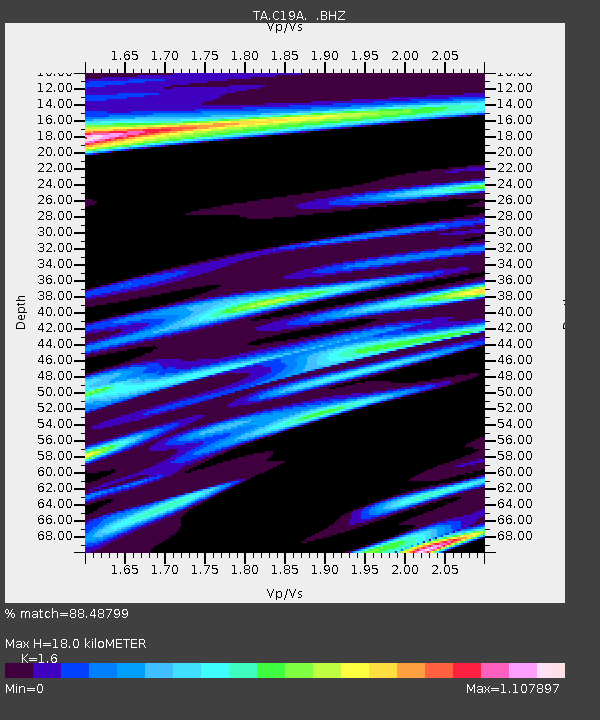
| Estimated Moho Depth: |
18.0 km |
| Estimated Crust Vp/Vs: |
1.60 |
| Assumed Crust Vp: |
6.518 km/s |
| Estimated Crust Vs: |
4.074 km/s |
| Estimated Crust Poisson's Ratio: |
0.18 |
|
| Radial Match: |
88.48799 % |
| Radial Bump: |
396 |
| Transverse Match: |
76.07831 % |
| Transverse Bump: |
400 |
| SOD ConfigId: |
2648 |
| Insert Time: |
2010-03-06 11:43:06.691 +0000 |
| GWidth: |
2.5 |
| Max Bumps: |
400 |
| Tol: |
0.001 |
|

Signal To Noise
| Channel | StoN | STA | LTA |
| TA:C19A: :BHZ:20090712T06:23:14.574019Z | 18.705782 | 1.5179297E-6 | 8.1147626E-8 |
| TA:C19A: :BHN:20090712T06:23:14.574019Z | 1.4251456 | 1.5037045E-7 | 1.0551234E-7 |
| TA:C19A: :BHE:20090712T06:23:14.574019Z | 2.0751104 | 1.8879034E-7 | 9.097846E-8 |
| Arrivals |
| Ps | 1.7 SECOND |
| PpPs | 6.9 SECOND |
| PsPs/PpSs | 8.6 SECOND |


