You are here: Home > Network List > N4 - Central and EAstern US Network Stations List
> Station L34B Svendsen Farm, Lyons, NE, USA > Earthquake Result Viewer
L34B Svendsen Farm, Lyons, NE, USA - Earthquake Result Viewer
| Earthquake location: |
Near S. Coast Of Western Honshu |
| Earthquake latitude/longitude: |
34.8/135.6 |
| Earthquake time(UTC): |
2018/06/17 (168) 22:58:35 GMT |
| Earthquake Depth: |
11 km |
| Earthquake Magnitude: |
5.5 Mww |
| Earthquake Catalog/Contributor: |
NEIC PDE/us |
|
| Network: |
N4 Central and EAstern US Network |
| Station: |
L34B Svendsen Farm, Lyons, NE, USA |
| Lat/Lon: |
41.97 N/96.38 W |
| Elevation: |
414 m |
|
| Distance: |
89.9 deg |
| Az: |
35.985 deg |
| Baz: |
319.599 deg |
| Ray Param: |
0.04170862 |
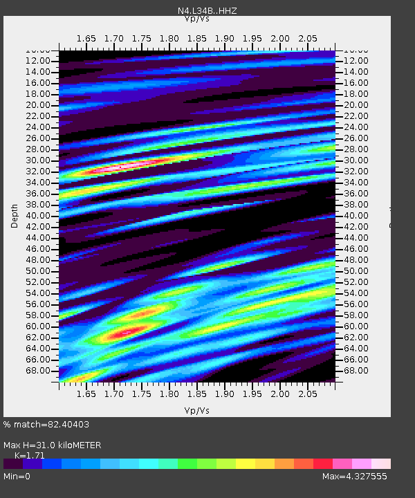
| Estimated Moho Depth: |
31.0 km |
| Estimated Crust Vp/Vs: |
1.71 |
| Assumed Crust Vp: |
6.498 km/s |
| Estimated Crust Vs: |
3.8 km/s |
| Estimated Crust Poisson's Ratio: |
0.24 |
|
| Radial Match: |
82.40403 % |
| Radial Bump: |
400 |
| Transverse Match: |
59.332336 % |
| Transverse Bump: |
400 |
| SOD ConfigId: |
13570011 |
| Insert Time: |
2019-04-30 09:38:22.420 +0000 |
| GWidth: |
2.5 |
| Max Bumps: |
400 |
| Tol: |
0.001 |
|

Signal To Noise
| Channel | StoN | STA | LTA |
| N4:L34B: :HHZ:20180617T23:11:02.399998Z | 6.2210975 | 5.876478E-7 | 9.4460475E-8 |
| N4:L34B: :HHN:20180617T23:11:02.399998Z | 2.6905465 | 3.9422866E-7 | 1.4652363E-7 |
| N4:L34B: :HHE:20180617T23:11:02.399998Z | 2.5268254 | 4.0939872E-7 | 1.6202098E-7 |
| Arrivals |
| Ps | 3.5 SECOND |
| PpPs | 13 SECOND |
| PsPs/PpSs | 16 SECOND |


