You are here: Home > Network List > US - United States National Seismic Network Stations List
> Station WMOK Wichita Mountains, Oklahoma, USA > Earthquake Result Viewer
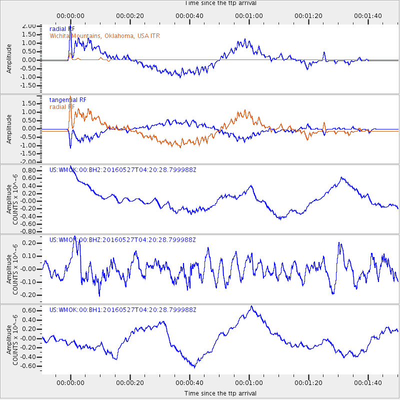
WMOK Wichita Mountains, Oklahoma, USA - Earthquake Result Viewer
*The percent match for this event was below the threshold and hence no stack was calculated.
| Earthquake location: |
Fiji Islands Region |
| Earthquake latitude/longitude: |
-20.8/-178.7 |
| Earthquake time(UTC): |
2016/05/27 (148) 04:08:44 GMT |
| Earthquake Depth: |
572 km |
| Earthquake Magnitude: |
6.4 MO |
| Earthquake Catalog/Contributor: |
NEIC PDE/NEIC ALERT |
|
| Network: |
US United States National Seismic Network |
| Station: |
WMOK Wichita Mountains, Oklahoma, USA |
| Lat/Lon: |
34.74 N/98.78 W |
| Elevation: |
486 m |
|
| Distance: |
93.7 deg |
| Az: |
54.341 deg |
| Baz: |
247.353 deg |
| Ray Param: |
$rayparam |
*The percent match for this event was below the threshold and hence was not used in the summary stack. |
|
| Radial Match: |
41.374355 % |
| Radial Bump: |
400 |
| Transverse Match: |
49.622658 % |
| Transverse Bump: |
400 |
| SOD ConfigId: |
1475611 |
| Insert Time: |
2016-06-10 04:15:39.280 +0000 |
| GWidth: |
2.5 |
| Max Bumps: |
400 |
| Tol: |
0.001 |
|
Signal To Noise
| Channel | StoN | STA | LTA |
| US:WMOK:00:BHZ:20160527T04:20:28.799988Z | 1.9772772 | 1.4630906E-7 | 7.3995224E-8 |
| US:WMOK:00:BH1:20160527T04:20:28.799988Z | 1.3652331 | 3.9551435E-7 | 2.8970464E-7 |
| US:WMOK:00:BH2:20160527T04:20:28.799988Z | 1.4223696 | 3.423653E-7 | 2.4070067E-7 |
| Arrivals |
| Ps | |
| PpPs | |
| PsPs/PpSs | |


