You are here: Home > Network List > TA - USArray Transportable Network (new EarthScope stations) Stations List
> Station A22K Sinclair Lake, AK, USA > Earthquake Result Viewer
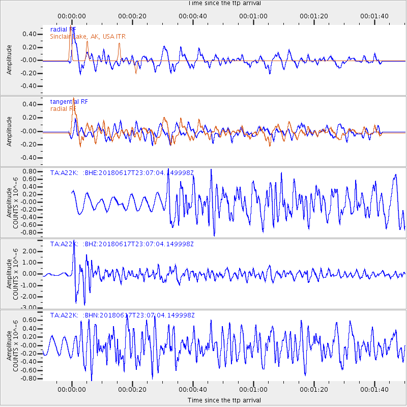
A22K Sinclair Lake, AK, USA - Earthquake Result Viewer
*The percent match for this event was below the threshold and hence no stack was calculated.
| Earthquake location: |
Near S. Coast Of Western Honshu |
| Earthquake latitude/longitude: |
34.8/135.6 |
| Earthquake time(UTC): |
2018/06/17 (168) 22:58:35 GMT |
| Earthquake Depth: |
11 km |
| Earthquake Magnitude: |
5.5 Mww |
| Earthquake Catalog/Contributor: |
NEIC PDE/us |
|
| Network: |
TA USArray Transportable Network (new EarthScope stations) |
| Station: |
A22K Sinclair Lake, AK, USA |
| Lat/Lon: |
71.00 N/154.97 W |
| Elevation: |
6.0 m |
|
| Distance: |
50.8 deg |
| Az: |
23.301 deg |
| Baz: |
263.547 deg |
| Ray Param: |
$rayparam |
*The percent match for this event was below the threshold and hence was not used in the summary stack. |
|
| Radial Match: |
78.57359 % |
| Radial Bump: |
400 |
| Transverse Match: |
72.47404 % |
| Transverse Bump: |
400 |
| SOD ConfigId: |
13570011 |
| Insert Time: |
2019-04-30 09:40:39.275 +0000 |
| GWidth: |
2.5 |
| Max Bumps: |
400 |
| Tol: |
0.001 |
|
Signal To Noise
| Channel | StoN | STA | LTA |
| TA:A22K: :BHZ:20180617T23:07:04.149998Z | 11.885981 | 1.3849698E-6 | 1.16521285E-7 |
| TA:A22K: :BHN:20180617T23:07:04.149998Z | 2.1109705 | 2.9885E-7 | 1.4156996E-7 |
| TA:A22K: :BHE:20180617T23:07:04.149998Z | 2.6058264 | 3.9415593E-7 | 1.5125947E-7 |
| Arrivals |
| Ps | |
| PpPs | |
| PsPs/PpSs | |


