You are here: Home > Network List > TA - USArray Transportable Network (new EarthScope stations) Stations List
> Station B22K Teshekpuk Lake, AK, USA > Earthquake Result Viewer
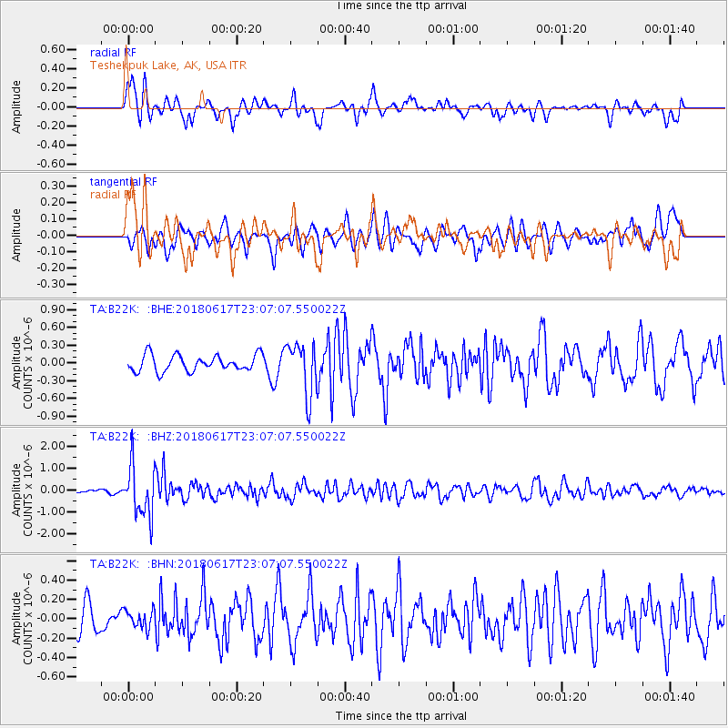
B22K Teshekpuk Lake, AK, USA - Earthquake Result Viewer
*The percent match for this event was below the threshold and hence no stack was calculated.
| Earthquake location: |
Near S. Coast Of Western Honshu |
| Earthquake latitude/longitude: |
34.8/135.6 |
| Earthquake time(UTC): |
2018/06/17 (168) 22:58:35 GMT |
| Earthquake Depth: |
11 km |
| Earthquake Magnitude: |
5.5 Mww |
| Earthquake Catalog/Contributor: |
NEIC PDE/us |
|
| Network: |
TA USArray Transportable Network (new EarthScope stations) |
| Station: |
B22K Teshekpuk Lake, AK, USA |
| Lat/Lon: |
70.34 N/153.42 W |
| Elevation: |
50 m |
|
| Distance: |
51.3 deg |
| Az: |
24.218 deg |
| Baz: |
265.589 deg |
| Ray Param: |
$rayparam |
*The percent match for this event was below the threshold and hence was not used in the summary stack. |
|
| Radial Match: |
77.784515 % |
| Radial Bump: |
360 |
| Transverse Match: |
67.61938 % |
| Transverse Bump: |
400 |
| SOD ConfigId: |
13570011 |
| Insert Time: |
2019-04-30 09:40:43.556 +0000 |
| GWidth: |
2.5 |
| Max Bumps: |
400 |
| Tol: |
0.001 |
|
Signal To Noise
| Channel | StoN | STA | LTA |
| TA:B22K: :BHZ:20180617T23:07:07.550022Z | 9.445988 | 1.140038E-6 | 1.2069019E-7 |
| TA:B22K: :BHN:20180617T23:07:07.550022Z | 0.57110626 | 9.3948564E-8 | 1.6450278E-7 |
| TA:B22K: :BHE:20180617T23:07:07.550022Z | 3.2330818 | 4.4589547E-7 | 1.3791654E-7 |
| Arrivals |
| Ps | |
| PpPs | |
| PsPs/PpSs | |


