You are here: Home > Network List > TA - USArray Transportable Network (new EarthScope stations) Stations List
> Station D19K Kuna River, AK, USA > Earthquake Result Viewer
D19K Kuna River, AK, USA - Earthquake Result Viewer
| Earthquake location: |
Near S. Coast Of Western Honshu |
| Earthquake latitude/longitude: |
34.8/135.6 |
| Earthquake time(UTC): |
2018/06/17 (168) 22:58:35 GMT |
| Earthquake Depth: |
11 km |
| Earthquake Magnitude: |
5.5 Mww |
| Earthquake Catalog/Contributor: |
NEIC PDE/us |
|
| Network: |
TA USArray Transportable Network (new EarthScope stations) |
| Station: |
D19K Kuna River, AK, USA |
| Lat/Lon: |
68.49 N/158.12 W |
| Elevation: |
671 m |
|
| Distance: |
49.4 deg |
| Az: |
26.39 deg |
| Baz: |
262.583 deg |
| Ray Param: |
0.06871318 |
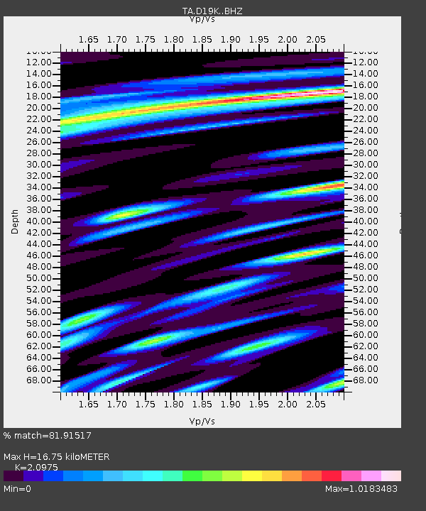
| Estimated Moho Depth: |
16.75 km |
| Estimated Crust Vp/Vs: |
2.10 |
| Assumed Crust Vp: |
6.221 km/s |
| Estimated Crust Vs: |
2.966 km/s |
| Estimated Crust Poisson's Ratio: |
0.35 |
|
| Radial Match: |
81.91517 % |
| Radial Bump: |
400 |
| Transverse Match: |
73.98428 % |
| Transverse Bump: |
400 |
| SOD ConfigId: |
13570011 |
| Insert Time: |
2019-04-30 09:40:52.706 +0000 |
| GWidth: |
2.5 |
| Max Bumps: |
400 |
| Tol: |
0.001 |
|

Signal To Noise
| Channel | StoN | STA | LTA |
| TA:D19K: :BHZ:20180617T23:06:53.625004Z | 9.975754 | 1.0935054E-6 | 1.09616316E-7 |
| TA:D19K: :BHN:20180617T23:06:53.625004Z | 2.2242723 | 1.7036245E-7 | 7.659245E-8 |
| TA:D19K: :BHE:20180617T23:06:53.625004Z | 4.5547385 | 4.4361292E-7 | 9.739592E-8 |
| Arrivals |
| Ps | 3.1 SECOND |
| PpPs | 8.0 SECOND |
| PsPs/PpSs | 11 SECOND |


