You are here: Home > Network List > TA - USArray Transportable Network (new EarthScope stations) Stations List
> Station H22K Ishtalitna Creek, AK, USA > Earthquake Result Viewer
H22K Ishtalitna Creek, AK, USA - Earthquake Result Viewer
| Earthquake location: |
Near S. Coast Of Western Honshu |
| Earthquake latitude/longitude: |
34.8/135.6 |
| Earthquake time(UTC): |
2018/06/17 (168) 22:58:35 GMT |
| Earthquake Depth: |
11 km |
| Earthquake Magnitude: |
5.5 Mww |
| Earthquake Catalog/Contributor: |
NEIC PDE/us |
|
| Network: |
TA USArray Transportable Network (new EarthScope stations) |
| Station: |
H22K Ishtalitna Creek, AK, USA |
| Lat/Lon: |
65.89 N/151.38 W |
| Elevation: |
561 m |
|
| Distance: |
51.9 deg |
| Az: |
29.947 deg |
| Baz: |
271.047 deg |
| Ray Param: |
0.06711257 |
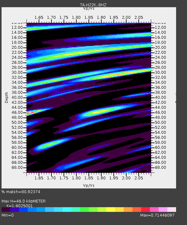
| Estimated Moho Depth: |
46.0 km |
| Estimated Crust Vp/Vs: |
1.60 |
| Assumed Crust Vp: |
6.566 km/s |
| Estimated Crust Vs: |
4.097 km/s |
| Estimated Crust Poisson's Ratio: |
0.18 |
|
| Radial Match: |
80.92374 % |
| Radial Bump: |
400 |
| Transverse Match: |
68.59595 % |
| Transverse Bump: |
400 |
| SOD ConfigId: |
13570011 |
| Insert Time: |
2019-04-30 09:41:28.195 +0000 |
| GWidth: |
2.5 |
| Max Bumps: |
400 |
| Tol: |
0.001 |
|

Signal To Noise
| Channel | StoN | STA | LTA |
| TA:H22K: :BHZ:20180617T23:07:12.274998Z | 7.532084 | 7.7719676E-7 | 1.03184824E-7 |
| TA:H22K: :BHN:20180617T23:07:12.274998Z | 1.5737336 | 1.2167541E-7 | 7.73164E-8 |
| TA:H22K: :BHE:20180617T23:07:12.274998Z | 3.2874227 | 4.2623017E-7 | 1.2965481E-7 |
| Arrivals |
| Ps | 4.5 SECOND |
| PpPs | 17 SECOND |
| PsPs/PpSs | 22 SECOND |


