You are here: Home > Network List > TA - USArray Transportable Network (new EarthScope stations) Stations List
> Station H31M Peel River, Yukon, CAN > Earthquake Result Viewer
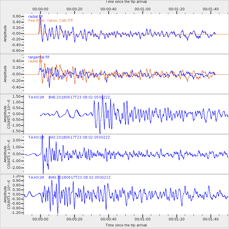
H31M Peel River, Yukon, CAN - Earthquake Result Viewer
*The percent match for this event was below the threshold and hence no stack was calculated.
| Earthquake location: |
Near S. Coast Of Western Honshu |
| Earthquake latitude/longitude: |
34.8/135.6 |
| Earthquake time(UTC): |
2018/06/17 (168) 22:58:35 GMT |
| Earthquake Depth: |
11 km |
| Earthquake Magnitude: |
5.5 Mww |
| Earthquake Catalog/Contributor: |
NEIC PDE/us |
|
| Network: |
TA USArray Transportable Network (new EarthScope stations) |
| Station: |
H31M Peel River, Yukon, CAN |
| Lat/Lon: |
65.81 N/134.34 W |
| Elevation: |
642 m |
|
| Distance: |
58.8 deg |
| Az: |
28.799 deg |
| Baz: |
285.939 deg |
| Ray Param: |
$rayparam |
*The percent match for this event was below the threshold and hence was not used in the summary stack. |
|
| Radial Match: |
74.03934 % |
| Radial Bump: |
400 |
| Transverse Match: |
75.34923 % |
| Transverse Bump: |
400 |
| SOD ConfigId: |
13570011 |
| Insert Time: |
2019-04-30 09:41:31.480 +0000 |
| GWidth: |
2.5 |
| Max Bumps: |
400 |
| Tol: |
0.001 |
|
Signal To Noise
| Channel | StoN | STA | LTA |
| TA:H31M: :BHZ:20180617T23:08:02.050022Z | 13.291619 | 1.2299175E-6 | 9.2533305E-8 |
| TA:H31M: :BHN:20180617T23:08:02.050022Z | 2.2699897 | 2.806605E-7 | 1.2363954E-7 |
| TA:H31M: :BHE:20180617T23:08:02.050022Z | 4.4275813 | 7.546365E-7 | 1.704399E-7 |
| Arrivals |
| Ps | |
| PpPs | |
| PsPs/PpSs | |


