You are here: Home > Network List > TA - USArray Transportable Network (new EarthScope stations) Stations List
> Station L15K Ungalak Mountain, AK, USA > Earthquake Result Viewer
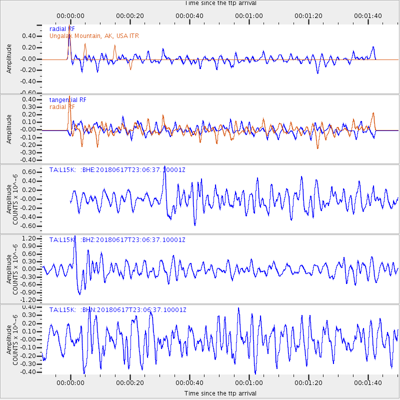
L15K Ungalak Mountain, AK, USA - Earthquake Result Viewer
*The percent match for this event was below the threshold and hence no stack was calculated.
| Earthquake location: |
Near S. Coast Of Western Honshu |
| Earthquake latitude/longitude: |
34.8/135.6 |
| Earthquake time(UTC): |
2018/06/17 (168) 22:58:35 GMT |
| Earthquake Depth: |
11 km |
| Earthquake Magnitude: |
5.5 Mww |
| Earthquake Catalog/Contributor: |
NEIC PDE/us |
|
| Network: |
TA USArray Transportable Network (new EarthScope stations) |
| Station: |
L15K Ungalak Mountain, AK, USA |
| Lat/Lon: |
61.68 N/161.49 W |
| Elevation: |
219 m |
|
| Distance: |
47.3 deg |
| Az: |
35.304 deg |
| Baz: |
265.455 deg |
| Ray Param: |
$rayparam |
*The percent match for this event was below the threshold and hence was not used in the summary stack. |
|
| Radial Match: |
63.299034 % |
| Radial Bump: |
400 |
| Transverse Match: |
61.382553 % |
| Transverse Bump: |
390 |
| SOD ConfigId: |
13570011 |
| Insert Time: |
2019-04-30 09:41:49.495 +0000 |
| GWidth: |
2.5 |
| Max Bumps: |
400 |
| Tol: |
0.001 |
|
Signal To Noise
| Channel | StoN | STA | LTA |
| TA:L15K: :BHZ:20180617T23:06:37.10001Z | 3.919578 | 6.1177093E-7 | 1.560808E-7 |
| TA:L15K: :BHN:20180617T23:06:37.10001Z | 1.0009074 | 1.598069E-7 | 1.5966202E-7 |
| TA:L15K: :BHE:20180617T23:06:37.10001Z | 2.4843233 | 3.327106E-7 | 1.3392405E-7 |
| Arrivals |
| Ps | |
| PpPs | |
| PsPs/PpSs | |


