You are here: Home > Network List > TA - USArray Transportable Network (new EarthScope stations) Stations List
> Station M31M Drury Creek, Yukon, CA > Earthquake Result Viewer
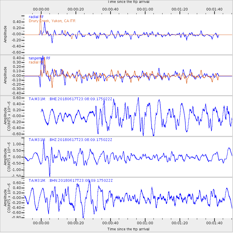
M31M Drury Creek, Yukon, CA - Earthquake Result Viewer
*The percent match for this event was below the threshold and hence no stack was calculated.
| Earthquake location: |
Near S. Coast Of Western Honshu |
| Earthquake latitude/longitude: |
34.8/135.6 |
| Earthquake time(UTC): |
2018/06/17 (168) 22:58:35 GMT |
| Earthquake Depth: |
11 km |
| Earthquake Magnitude: |
5.5 Mww |
| Earthquake Catalog/Contributor: |
NEIC PDE/us |
|
| Network: |
TA USArray Transportable Network (new EarthScope stations) |
| Station: |
M31M Drury Creek, Yukon, CA |
| Lat/Lon: |
62.20 N/134.39 W |
| Elevation: |
639 m |
|
| Distance: |
59.9 deg |
| Az: |
32.83 deg |
| Baz: |
287.952 deg |
| Ray Param: |
$rayparam |
*The percent match for this event was below the threshold and hence was not used in the summary stack. |
|
| Radial Match: |
68.805756 % |
| Radial Bump: |
400 |
| Transverse Match: |
76.50424 % |
| Transverse Bump: |
400 |
| SOD ConfigId: |
13570011 |
| Insert Time: |
2019-04-30 09:42:02.970 +0000 |
| GWidth: |
2.5 |
| Max Bumps: |
400 |
| Tol: |
0.001 |
|
Signal To Noise
| Channel | StoN | STA | LTA |
| TA:M31M: :BHZ:20180617T23:08:09.175022Z | 2.3594227 | 5.1339845E-7 | 2.1759494E-7 |
| TA:M31M: :BHN:20180617T23:08:09.175022Z | 1.1514078 | 2.8459044E-7 | 2.4716735E-7 |
| TA:M31M: :BHE:20180617T23:08:09.175022Z | 1.8230066 | 2.4238068E-7 | 1.3295654E-7 |
| Arrivals |
| Ps | |
| PpPs | |
| PsPs/PpSs | |


