You are here: Home > Network List > TA - USArray Transportable Network (new EarthScope stations) Stations List
> Station Q24A Divide, CO, USA > Earthquake Result Viewer
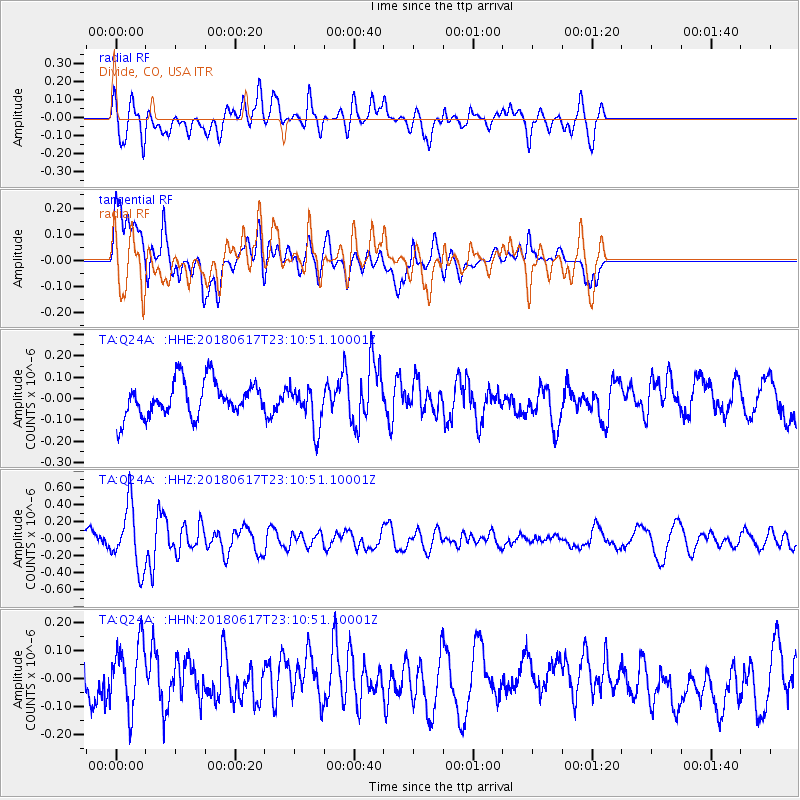
Q24A Divide, CO, USA - Earthquake Result Viewer
*The percent match for this event was below the threshold and hence no stack was calculated.
| Earthquake location: |
Near S. Coast Of Western Honshu |
| Earthquake latitude/longitude: |
34.8/135.6 |
| Earthquake time(UTC): |
2018/06/17 (168) 22:58:35 GMT |
| Earthquake Depth: |
11 km |
| Earthquake Magnitude: |
5.5 Mww |
| Earthquake Catalog/Contributor: |
NEIC PDE/us |
|
| Network: |
TA USArray Transportable Network (new EarthScope stations) |
| Station: |
Q24A Divide, CO, USA |
| Lat/Lon: |
38.96 N/105.15 W |
| Elevation: |
2775 m |
|
| Distance: |
87.5 deg |
| Az: |
42.914 deg |
| Baz: |
314.072 deg |
| Ray Param: |
$rayparam |
*The percent match for this event was below the threshold and hence was not used in the summary stack. |
|
| Radial Match: |
49.013367 % |
| Radial Bump: |
400 |
| Transverse Match: |
55.43418 % |
| Transverse Bump: |
400 |
| SOD ConfigId: |
13570011 |
| Insert Time: |
2019-04-30 09:42:25.091 +0000 |
| GWidth: |
2.5 |
| Max Bumps: |
400 |
| Tol: |
0.001 |
|
Signal To Noise
| Channel | StoN | STA | LTA |
| TA:Q24A: :HHZ:20180617T23:10:51.10001Z | 3.394603 | 3.6695243E-7 | 1.0809878E-7 |
| TA:Q24A: :HHN:20180617T23:10:51.10001Z | 1.0707366 | 1.1310795E-7 | 1.0563564E-7 |
| TA:Q24A: :HHE:20180617T23:10:51.10001Z | 1.2115029 | 9.755022E-8 | 8.052001E-8 |
| Arrivals |
| Ps | |
| PpPs | |
| PsPs/PpSs | |


