You are here: Home > Network List > AU - Australian Seismological Centre Stations List
> Station PSA00 Pilbara Seismic Array Element A0 > Earthquake Result Viewer
PSA00 Pilbara Seismic Array Element A0 - Earthquake Result Viewer
| Earthquake location: |
South Of Fiji Islands |
| Earthquake latitude/longitude: |
-22.0/-178.2 |
| Earthquake time(UTC): |
2016/05/28 (149) 05:38:51 GMT |
| Earthquake Depth: |
417 km |
| Earthquake Magnitude: |
6.6 MO |
| Earthquake Catalog/Contributor: |
NEIC PDE/NEIC ALERT |
|
| Network: |
AU Australian Seismological Centre |
| Station: |
PSA00 Pilbara Seismic Array Element A0 |
| Lat/Lon: |
21.57 S/119.85 E |
| Elevation: |
305 m |
|
| Distance: |
57.2 deg |
| Az: |
257.894 deg |
| Baz: |
102.905 deg |
| Ray Param: |
0.062083002 |
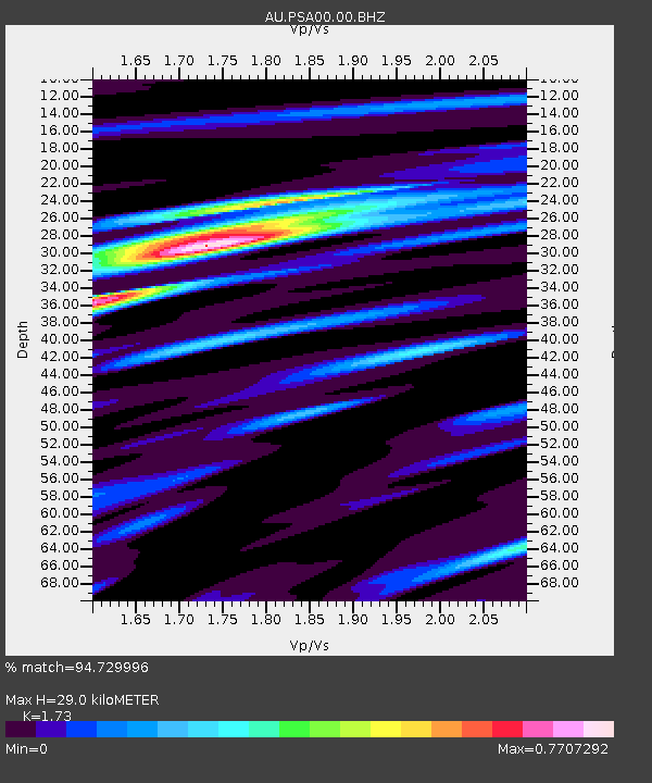
| Estimated Moho Depth: |
29.0 km |
| Estimated Crust Vp/Vs: |
1.73 |
| Assumed Crust Vp: |
6.464 km/s |
| Estimated Crust Vs: |
3.736 km/s |
| Estimated Crust Poisson's Ratio: |
0.25 |
|
| Radial Match: |
94.729996 % |
| Radial Bump: |
386 |
| Transverse Match: |
83.7244 % |
| Transverse Bump: |
400 |
| SOD ConfigId: |
1475611 |
| Insert Time: |
2016-06-11 05:39:03.147 +0000 |
| GWidth: |
2.5 |
| Max Bumps: |
400 |
| Tol: |
0.001 |
|

Signal To Noise
| Channel | StoN | STA | LTA |
| AU:PSA00:00:BHZ:20160528T05:47:25.81897Z | 37.240753 | 1.2864099E-5 | 3.454307E-7 |
| AU:PSA00:00:BH1:20160528T05:47:25.81897Z | 26.266691 | 6.6960974E-6 | 2.5492733E-7 |
| AU:PSA00:00:BH2:20160528T05:47:25.81897Z | 3.7089171 | 1.2718589E-6 | 3.4291918E-7 |
| Arrivals |
| Ps | 3.4 SECOND |
| PpPs | 12 SECOND |
| PsPs/PpSs | 15 SECOND |


