You are here: Home > Network List > N4 - Central and EAstern US Network Stations List
> Station G45A Suttons Bay, MI, USA > Earthquake Result Viewer
G45A Suttons Bay, MI, USA - Earthquake Result Viewer
| Earthquake location: |
Guatemala |
| Earthquake latitude/longitude: |
14.1/-90.7 |
| Earthquake time(UTC): |
2018/06/18 (169) 02:32:55 GMT |
| Earthquake Depth: |
98 km |
| Earthquake Magnitude: |
5.7 Mww |
| Earthquake Catalog/Contributor: |
NEIC PDE/us |
|
| Network: |
N4 Central and EAstern US Network |
| Station: |
G45A Suttons Bay, MI, USA |
| Lat/Lon: |
45.04 N/85.66 W |
| Elevation: |
284 m |
|
| Distance: |
31.1 deg |
| Az: |
6.945 deg |
| Baz: |
189.523 deg |
| Ray Param: |
0.07895894 |
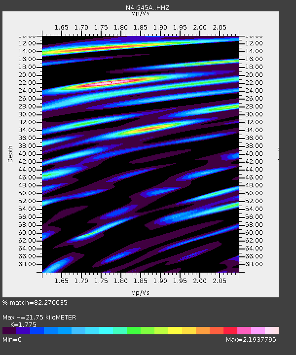
| Estimated Moho Depth: |
21.75 km |
| Estimated Crust Vp/Vs: |
1.77 |
| Assumed Crust Vp: |
6.483 km/s |
| Estimated Crust Vs: |
3.652 km/s |
| Estimated Crust Poisson's Ratio: |
0.27 |
|
| Radial Match: |
82.270035 % |
| Radial Bump: |
400 |
| Transverse Match: |
62.698315 % |
| Transverse Bump: |
400 |
| SOD ConfigId: |
13570011 |
| Insert Time: |
2019-04-30 09:48:37.343 +0000 |
| GWidth: |
2.5 |
| Max Bumps: |
400 |
| Tol: |
0.001 |
|

Signal To Noise
| Channel | StoN | STA | LTA |
| N4:G45A: :HHZ:20180618T02:38:34.670015Z | 10.498635 | 1.18425E-6 | 1.1280037E-7 |
| N4:G45A: :HHN:20180618T02:38:34.670015Z | 6.645866 | 8.1871013E-7 | 1.231909E-7 |
| N4:G45A: :HHE:20180618T02:38:34.670015Z | 4.6756334 | 6.388042E-7 | 1.3662408E-7 |
| Arrivals |
| Ps | 2.8 SECOND |
| PpPs | 8.6 SECOND |
| PsPs/PpSs | 11 SECOND |


