You are here: Home > Network List > N4 - Central and EAstern US Network Stations List
> Station I45A Fountain, MI, USA > Earthquake Result Viewer
I45A Fountain, MI, USA - Earthquake Result Viewer
| Earthquake location: |
Guatemala |
| Earthquake latitude/longitude: |
14.1/-90.7 |
| Earthquake time(UTC): |
2018/06/18 (169) 02:32:55 GMT |
| Earthquake Depth: |
98 km |
| Earthquake Magnitude: |
5.7 Mww |
| Earthquake Catalog/Contributor: |
NEIC PDE/us |
|
| Network: |
N4 Central and EAstern US Network |
| Station: |
I45A Fountain, MI, USA |
| Lat/Lon: |
44.04 N/86.23 W |
| Elevation: |
215 m |
|
| Distance: |
30.0 deg |
| Az: |
6.455 deg |
| Baz: |
188.698 deg |
| Ray Param: |
0.07927305 |
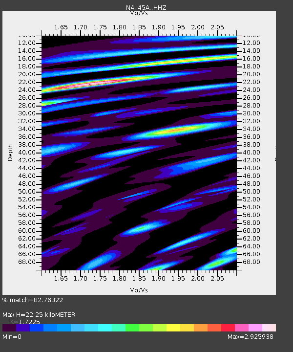
| Estimated Moho Depth: |
22.25 km |
| Estimated Crust Vp/Vs: |
1.72 |
| Assumed Crust Vp: |
6.53 km/s |
| Estimated Crust Vs: |
3.791 km/s |
| Estimated Crust Poisson's Ratio: |
0.25 |
|
| Radial Match: |
82.76322 % |
| Radial Bump: |
400 |
| Transverse Match: |
60.855186 % |
| Transverse Bump: |
400 |
| SOD ConfigId: |
13570011 |
| Insert Time: |
2019-04-30 09:48:40.927 +0000 |
| GWidth: |
2.5 |
| Max Bumps: |
400 |
| Tol: |
0.001 |
|

Signal To Noise
| Channel | StoN | STA | LTA |
| N4:I45A: :HHZ:20180618T02:38:25.380006Z | 4.4132786 | 7.685198E-7 | 1.7413805E-7 |
| N4:I45A: :HHN:20180618T02:38:25.380006Z | 3.541953 | 1.020151E-6 | 2.8801935E-7 |
| N4:I45A: :HHE:20180618T02:38:25.380006Z | 1.4571643 | 3.8290003E-7 | 2.6277067E-7 |
| Arrivals |
| Ps | 2.7 SECOND |
| PpPs | 8.5 SECOND |
| PsPs/PpSs | 11 SECOND |


