You are here: Home > Network List > N4 - Central and EAstern US Network Stations List
> Station L59A Walton, NY, USA > Earthquake Result Viewer
L59A Walton, NY, USA - Earthquake Result Viewer
| Earthquake location: |
Guatemala |
| Earthquake latitude/longitude: |
14.1/-90.7 |
| Earthquake time(UTC): |
2018/06/18 (169) 02:32:55 GMT |
| Earthquake Depth: |
98 km |
| Earthquake Magnitude: |
5.7 Mww |
| Earthquake Catalog/Contributor: |
NEIC PDE/us |
|
| Network: |
N4 Central and EAstern US Network |
| Station: |
L59A Walton, NY, USA |
| Lat/Lon: |
42.19 N/75.04 W |
| Elevation: |
677 m |
|
| Distance: |
31.1 deg |
| Az: |
22.884 deg |
| Baz: |
210.505 deg |
| Ray Param: |
0.07897202 |
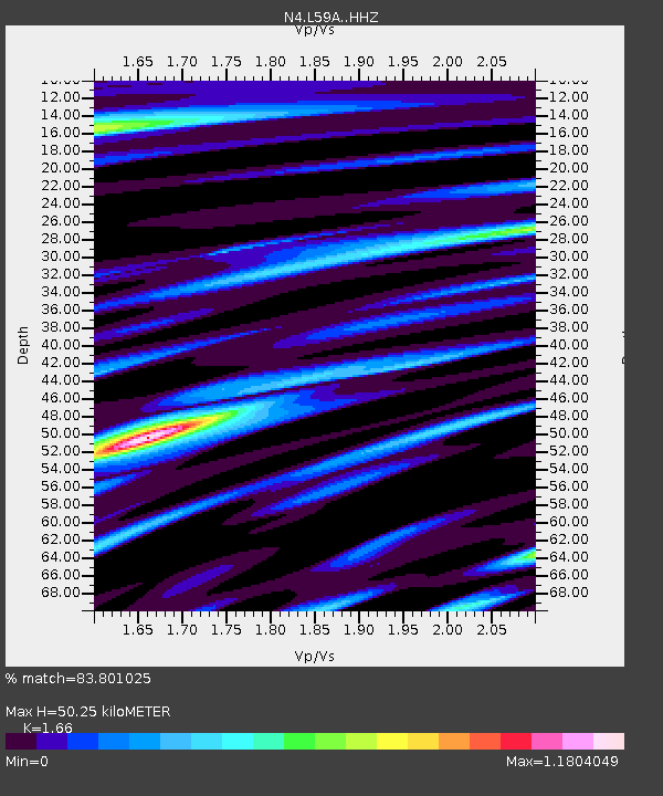
| Estimated Moho Depth: |
50.25 km |
| Estimated Crust Vp/Vs: |
1.66 |
| Assumed Crust Vp: |
6.419 km/s |
| Estimated Crust Vs: |
3.867 km/s |
| Estimated Crust Poisson's Ratio: |
0.22 |
|
| Radial Match: |
83.801025 % |
| Radial Bump: |
323 |
| Transverse Match: |
56.05247 % |
| Transverse Bump: |
354 |
| SOD ConfigId: |
13570011 |
| Insert Time: |
2019-04-30 09:48:48.478 +0000 |
| GWidth: |
2.5 |
| Max Bumps: |
400 |
| Tol: |
0.001 |
|

Signal To Noise
| Channel | StoN | STA | LTA |
| N4:L59A: :HHZ:20180618T02:38:34.399995Z | 9.563495 | 1.0733021E-6 | 1.12229074E-7 |
| N4:L59A: :HHN:20180618T02:38:34.399995Z | 4.607396 | 5.246345E-7 | 1.138679E-7 |
| N4:L59A: :HHE:20180618T02:38:34.399995Z | 5.1927667 | 4.2236834E-7 | 8.1337824E-8 |
| Arrivals |
| Ps | 5.6 SECOND |
| PpPs | 19 SECOND |
| PsPs/PpSs | 25 SECOND |


