You are here: Home > Network List > TA - USArray Transportable Network (new EarthScope stations) Stations List
> Station F21K Alatna River, AK, USA > Earthquake Result Viewer
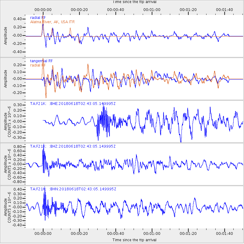
F21K Alatna River, AK, USA - Earthquake Result Viewer
*The percent match for this event was below the threshold and hence no stack was calculated.
| Earthquake location: |
Guatemala |
| Earthquake latitude/longitude: |
14.1/-90.7 |
| Earthquake time(UTC): |
2018/06/18 (169) 02:32:55 GMT |
| Earthquake Depth: |
98 km |
| Earthquake Magnitude: |
5.7 Mww |
| Earthquake Catalog/Contributor: |
NEIC PDE/us |
|
| Network: |
TA USArray Transportable Network (new EarthScope stations) |
| Station: |
F21K Alatna River, AK, USA |
| Lat/Lon: |
67.22 N/153.48 W |
| Elevation: |
597 m |
|
| Distance: |
66.7 deg |
| Az: |
337.846 deg |
| Baz: |
110.025 deg |
| Ray Param: |
$rayparam |
*The percent match for this event was below the threshold and hence was not used in the summary stack. |
|
| Radial Match: |
67.79868 % |
| Radial Bump: |
370 |
| Transverse Match: |
49.934372 % |
| Transverse Bump: |
400 |
| SOD ConfigId: |
13570011 |
| Insert Time: |
2019-04-30 09:49:58.540 +0000 |
| GWidth: |
2.5 |
| Max Bumps: |
400 |
| Tol: |
0.001 |
|
Signal To Noise
| Channel | StoN | STA | LTA |
| TA:F21K: :BHZ:20180618T02:43:05.149995Z | 4.9964743 | 2.9847175E-7 | 5.973647E-8 |
| TA:F21K: :BHN:20180618T02:43:05.149995Z | 2.9235046 | 1.4655572E-7 | 5.013015E-8 |
| TA:F21K: :BHE:20180618T02:43:05.149995Z | 3.427967 | 1.473332E-7 | 4.2979757E-8 |
| Arrivals |
| Ps | |
| PpPs | |
| PsPs/PpSs | |


