You are here: Home > Network List > AU - Australian Seismological Centre Stations List
> Station PSAD3 Pilbara Seismic Array Element D3 > Earthquake Result Viewer
PSAD3 Pilbara Seismic Array Element D3 - Earthquake Result Viewer
| Earthquake location: |
South Of Fiji Islands |
| Earthquake latitude/longitude: |
-22.0/-178.2 |
| Earthquake time(UTC): |
2016/05/28 (149) 05:38:51 GMT |
| Earthquake Depth: |
417 km |
| Earthquake Magnitude: |
6.6 MO |
| Earthquake Catalog/Contributor: |
NEIC PDE/NEIC ALERT |
|
| Network: |
AU Australian Seismological Centre |
| Station: |
PSAD3 Pilbara Seismic Array Element D3 |
| Lat/Lon: |
21.64 S/119.78 E |
| Elevation: |
327 m |
|
| Distance: |
57.2 deg |
| Az: |
257.797 deg |
| Baz: |
102.877 deg |
| Ray Param: |
0.06205504 |
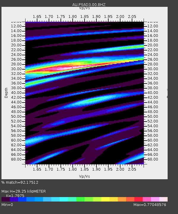
| Estimated Moho Depth: |
29.25 km |
| Estimated Crust Vp/Vs: |
1.80 |
| Assumed Crust Vp: |
6.464 km/s |
| Estimated Crust Vs: |
3.596 km/s |
| Estimated Crust Poisson's Ratio: |
0.28 |
|
| Radial Match: |
92.17512 % |
| Radial Bump: |
290 |
| Transverse Match: |
74.46362 % |
| Transverse Bump: |
400 |
| SOD ConfigId: |
1475611 |
| Insert Time: |
2016-06-11 05:39:39.583 +0000 |
| GWidth: |
2.5 |
| Max Bumps: |
400 |
| Tol: |
0.001 |
|

Signal To Noise
| Channel | StoN | STA | LTA |
| AU:PSAD3:00:BHZ:20160528T05:47:26.143982Z | 48.154083 | 1.3407146E-5 | 2.784218E-7 |
| AU:PSAD3:00:BH1:20160528T05:47:26.143982Z | 15.990008 | 3.823045E-6 | 2.3908964E-7 |
| AU:PSAD3:00:BH2:20160528T05:47:26.143982Z | 21.33473 | 4.9857636E-6 | 2.3369236E-7 |
| Arrivals |
| Ps | 3.8 SECOND |
| PpPs | 12 SECOND |
| PsPs/PpSs | 16 SECOND |


