You are here: Home > Network List > N4 - Central and EAstern US Network Stations List
> Station 154A Montrose, GA, USA > Earthquake Result Viewer
154A Montrose, GA, USA - Earthquake Result Viewer
| Earthquake location: |
Easter Island Region |
| Earthquake latitude/longitude: |
-29.9/-111.9 |
| Earthquake time(UTC): |
2018/06/18 (169) 07:09:41 GMT |
| Earthquake Depth: |
10 km |
| Earthquake Magnitude: |
5.9 Mww |
| Earthquake Catalog/Contributor: |
NEIC PDE/us |
|
| Network: |
N4 Central and EAstern US Network |
| Station: |
154A Montrose, GA, USA |
| Lat/Lon: |
32.61 N/83.11 W |
| Elevation: |
111 m |
|
| Distance: |
67.9 deg |
| Az: |
25.999 deg |
| Baz: |
206.8 deg |
| Ray Param: |
0.056642924 |
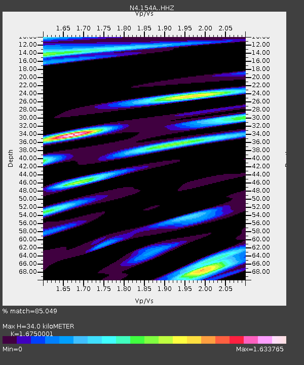
| Estimated Moho Depth: |
34.0 km |
| Estimated Crust Vp/Vs: |
1.68 |
| Assumed Crust Vp: |
6.565 km/s |
| Estimated Crust Vs: |
3.919 km/s |
| Estimated Crust Poisson's Ratio: |
0.22 |
|
| Radial Match: |
85.049 % |
| Radial Bump: |
372 |
| Transverse Match: |
65.20823 % |
| Transverse Bump: |
400 |
| SOD ConfigId: |
13570011 |
| Insert Time: |
2019-04-30 09:55:33.975 +0000 |
| GWidth: |
2.5 |
| Max Bumps: |
400 |
| Tol: |
0.001 |
|

Signal To Noise
| Channel | StoN | STA | LTA |
| N4:154A: :HHZ:20180618T07:20:09.210029Z | 2.5675657 | 2.2923442E-7 | 8.928084E-8 |
| N4:154A: :HHN:20180618T07:20:09.210029Z | 1.4851733 | 2.051052E-7 | 1.3810185E-7 |
| N4:154A: :HHE:20180618T07:20:09.210029Z | 0.885815 | 1.5568946E-7 | 1.7575844E-7 |
| Arrivals |
| Ps | 3.7 SECOND |
| PpPs | 13 SECOND |
| PsPs/PpSs | 17 SECOND |


