You are here: Home > Network List > N4 - Central and EAstern US Network Stations List
> Station Z47B Carrollton, AL, USA > Earthquake Result Viewer
Z47B Carrollton, AL, USA - Earthquake Result Viewer
| Earthquake location: |
Easter Island Region |
| Earthquake latitude/longitude: |
-29.9/-111.9 |
| Earthquake time(UTC): |
2018/06/18 (169) 07:09:41 GMT |
| Earthquake Depth: |
10 km |
| Earthquake Magnitude: |
5.9 Mww |
| Earthquake Catalog/Contributor: |
NEIC PDE/us |
|
| Network: |
N4 Central and EAstern US Network |
| Station: |
Z47B Carrollton, AL, USA |
| Lat/Lon: |
33.20 N/88.07 W |
| Elevation: |
64 m |
|
| Distance: |
66.7 deg |
| Az: |
21.622 deg |
| Baz: |
202.427 deg |
| Ray Param: |
0.057435572 |
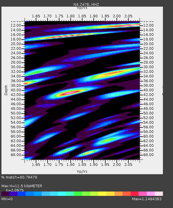
| Estimated Moho Depth: |
11.5 km |
| Estimated Crust Vp/Vs: |
2.10 |
| Assumed Crust Vp: |
6.201 km/s |
| Estimated Crust Vs: |
2.957 km/s |
| Estimated Crust Poisson's Ratio: |
0.35 |
|
| Radial Match: |
80.79478 % |
| Radial Bump: |
400 |
| Transverse Match: |
60.028297 % |
| Transverse Bump: |
400 |
| SOD ConfigId: |
13570011 |
| Insert Time: |
2019-04-30 09:56:27.447 +0000 |
| GWidth: |
2.5 |
| Max Bumps: |
400 |
| Tol: |
0.001 |
|

Signal To Noise
| Channel | StoN | STA | LTA |
| N4:Z47B: :HHZ:20180618T07:20:01.570015Z | 3.5276287 | 2.7659775E-7 | 7.840898E-8 |
| N4:Z47B: :HHN:20180618T07:20:01.570015Z | 2.470811 | 1.8145903E-7 | 7.344108E-8 |
| N4:Z47B: :HHE:20180618T07:20:01.570015Z | 1.0464609 | 1.11998595E-7 | 1.07026075E-7 |
| Arrivals |
| Ps | 2.1 SECOND |
| PpPs | 5.6 SECOND |
| PsPs/PpSs | 7.7 SECOND |


