You are here: Home > Network List > RV - Regional Alberta Seismic Observatory for Earthquake Studies Network Stations List
> Station HILA High Level, AB > Earthquake Result Viewer
HILA High Level, AB - Earthquake Result Viewer
| Earthquake location: |
Easter Island Region |
| Earthquake latitude/longitude: |
-29.9/-111.9 |
| Earthquake time(UTC): |
2018/06/18 (169) 07:09:41 GMT |
| Earthquake Depth: |
10 km |
| Earthquake Magnitude: |
5.9 Mww |
| Earthquake Catalog/Contributor: |
NEIC PDE/us |
|
| Network: |
RV Regional Alberta Seismic Observatory for Earthquake Studies Network |
| Station: |
HILA High Level, AB |
| Lat/Lon: |
58.56 N/117.02 W |
| Elevation: |
329 m |
|
| Distance: |
88.3 deg |
| Az: |
357.305 deg |
| Baz: |
175.535 deg |
| Ray Param: |
0.04272423 |
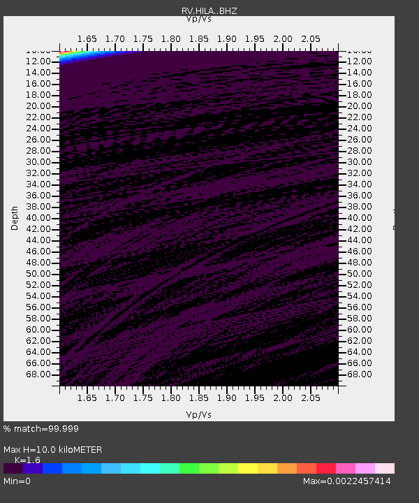
| Estimated Moho Depth: |
10.0 km |
| Estimated Crust Vp/Vs: |
1.60 |
| Assumed Crust Vp: |
6.498 km/s |
| Estimated Crust Vs: |
4.061 km/s |
| Estimated Crust Poisson's Ratio: |
0.18 |
|
| Radial Match: |
99.999 % |
| Radial Bump: |
2 |
| Transverse Match: |
99.993835 % |
| Transverse Bump: |
2 |
| SOD ConfigId: |
13570011 |
| Insert Time: |
2019-04-30 09:58:05.857 +0000 |
| GWidth: |
2.5 |
| Max Bumps: |
400 |
| Tol: |
0.001 |
|

Signal To Noise
| Channel | StoN | STA | LTA |
| RV:HILA: :BHZ:20180618T07:22:01.524971Z | 1.9156252 | 0.0035048237 | 0.0018295977 |
| RV:HILA: :BHN:20180618T07:22:01.524971Z | 1.9173471 | 0.0042955247 | 0.002240348 |
| RV:HILA: :BHE:20180618T07:22:01.524971Z | 1.9152063 | 0.002488802 | 0.0012994953 |
| Arrivals |
| Ps | 0.9 SECOND |
| PpPs | 3.9 SECOND |
| PsPs/PpSs | 4.9 SECOND |


