You are here: Home > Network List > TA - USArray Transportable Network (new EarthScope stations) Stations List
> Station TUL3 Leonard, OK, USA > Earthquake Result Viewer
TUL3 Leonard, OK, USA - Earthquake Result Viewer
| Earthquake location: |
Easter Island Region |
| Earthquake latitude/longitude: |
-29.9/-111.9 |
| Earthquake time(UTC): |
2018/06/18 (169) 07:09:41 GMT |
| Earthquake Depth: |
10 km |
| Earthquake Magnitude: |
5.9 Mww |
| Earthquake Catalog/Contributor: |
NEIC PDE/us |
|
| Network: |
TA USArray Transportable Network (new EarthScope stations) |
| Station: |
TUL3 Leonard, OK, USA |
| Lat/Lon: |
35.91 N/95.79 W |
| Elevation: |
265 m |
|
| Distance: |
67.2 deg |
| Az: |
14.12 deg |
| Baz: |
195.122 deg |
| Ray Param: |
0.0571006 |
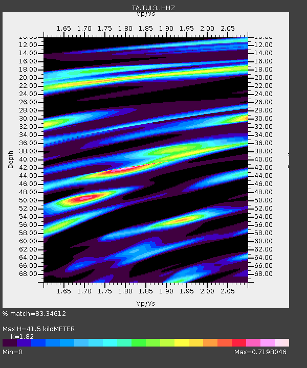
| Estimated Moho Depth: |
41.5 km |
| Estimated Crust Vp/Vs: |
1.82 |
| Assumed Crust Vp: |
6.498 km/s |
| Estimated Crust Vs: |
3.57 km/s |
| Estimated Crust Poisson's Ratio: |
0.28 |
|
| Radial Match: |
83.34612 % |
| Radial Bump: |
290 |
| Transverse Match: |
66.80067 % |
| Transverse Bump: |
355 |
| SOD ConfigId: |
13570011 |
| Insert Time: |
2019-04-30 09:58:46.122 +0000 |
| GWidth: |
2.5 |
| Max Bumps: |
400 |
| Tol: |
0.001 |
|
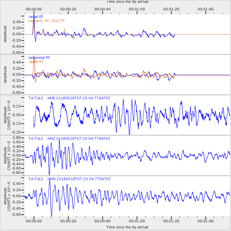
Signal To Noise
| Channel | StoN | STA | LTA |
| TA:TUL3: :HHZ:20180618T07:20:04.779976Z | 2.8650186 | 2.4588206E-7 | 8.582216E-8 |
| TA:TUL3: :HHN:20180618T07:20:04.779976Z | 2.2328722 | 1.6723851E-7 | 7.4898374E-8 |
| TA:TUL3: :HHE:20180618T07:20:04.779976Z | 0.5379765 | 4.2782464E-8 | 7.952478E-8 |
| Arrivals |
| Ps | 5.4 SECOND |
| PpPs | 17 SECOND |
| PsPs/PpSs | 23 SECOND |


