You are here: Home > Network List > UW - Pacific Northwest Regional Seismic Network Stations List
> Station UMAT Pilot Rock, OR, USA > Earthquake Result Viewer
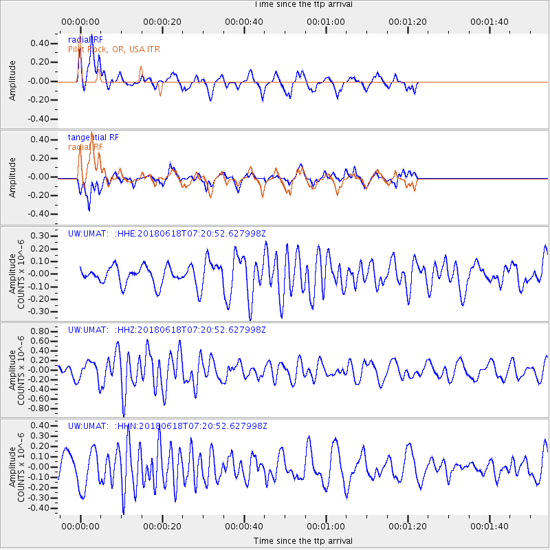
UMAT Pilot Rock, OR, USA - Earthquake Result Viewer
*The percent match for this event was below the threshold and hence no stack was calculated.
| Earthquake location: |
Easter Island Region |
| Earthquake latitude/longitude: |
-29.9/-111.9 |
| Earthquake time(UTC): |
2018/06/18 (169) 07:09:41 GMT |
| Earthquake Depth: |
10 km |
| Earthquake Magnitude: |
5.9 Mww |
| Earthquake Catalog/Contributor: |
NEIC PDE/us |
|
| Network: |
UW Pacific Northwest Regional Seismic Network |
| Station: |
UMAT Pilot Rock, OR, USA |
| Lat/Lon: |
45.29 N/118.96 W |
| Elevation: |
1318 m |
|
| Distance: |
75.1 deg |
| Az: |
354.834 deg |
| Baz: |
173.642 deg |
| Ray Param: |
$rayparam |
*The percent match for this event was below the threshold and hence was not used in the summary stack. |
|
| Radial Match: |
65.01088 % |
| Radial Bump: |
400 |
| Transverse Match: |
63.333115 % |
| Transverse Bump: |
400 |
| SOD ConfigId: |
13570011 |
| Insert Time: |
2019-04-30 09:59:30.420 +0000 |
| GWidth: |
2.5 |
| Max Bumps: |
400 |
| Tol: |
0.001 |
|
Signal To Noise
| Channel | StoN | STA | LTA |
| UW:UMAT: :HHZ:20180618T07:20:52.627998Z | 2.455028 | 2.0074508E-7 | 8.176895E-8 |
| UW:UMAT: :HHN:20180618T07:20:52.627998Z | 1.5282131 | 1.9029953E-7 | 1.245242E-7 |
| UW:UMAT: :HHE:20180618T07:20:52.627998Z | 1.7826997 | 1.16847225E-7 | 6.5545095E-8 |
| Arrivals |
| Ps | |
| PpPs | |
| PsPs/PpSs | |


