You are here: Home > Network List > YX16 - Raton Basin UNM Broadband Network Stations List
> Station UNM5 Southernmost CO Station > Earthquake Result Viewer
UNM5 Southernmost CO Station - Earthquake Result Viewer
| Earthquake location: |
Easter Island Region |
| Earthquake latitude/longitude: |
-29.9/-111.9 |
| Earthquake time(UTC): |
2018/06/18 (169) 07:09:41 GMT |
| Earthquake Depth: |
10 km |
| Earthquake Magnitude: |
5.9 Mww |
| Earthquake Catalog/Contributor: |
NEIC PDE/us |
|
| Network: |
YX Raton Basin UNM Broadband Network |
| Station: |
UNM5 Southernmost CO Station |
| Lat/Lon: |
37.12 N/104.78 W |
| Elevation: |
2035 m |
|
| Distance: |
67.0 deg |
| Az: |
6.155 deg |
| Baz: |
186.687 deg |
| Ray Param: |
0.057221733 |
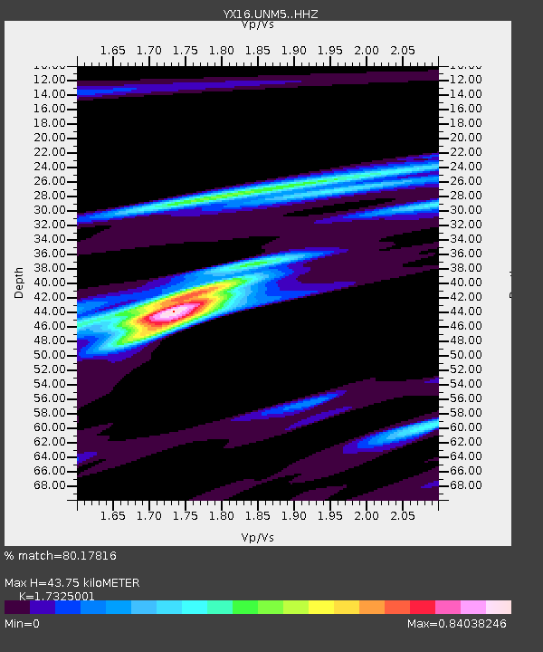
| Estimated Moho Depth: |
43.75 km |
| Estimated Crust Vp/Vs: |
1.73 |
| Assumed Crust Vp: |
6.316 km/s |
| Estimated Crust Vs: |
3.645 km/s |
| Estimated Crust Poisson's Ratio: |
0.25 |
|
| Radial Match: |
80.17816 % |
| Radial Bump: |
393 |
| Transverse Match: |
61.394802 % |
| Transverse Bump: |
400 |
| SOD ConfigId: |
13570011 |
| Insert Time: |
2019-04-30 10:00:05.866 +0000 |
| GWidth: |
2.5 |
| Max Bumps: |
400 |
| Tol: |
0.001 |
|

Signal To Noise
| Channel | StoN | STA | LTA |
| YX:UNM5: :HHZ:20180618T07:20:03.609993Z | 2.5599875 | 2.3798908E-7 | 9.296494E-8 |
| YX:UNM5: :HHN:20180618T07:20:03.609993Z | 1.0026703 | 9.451249E-8 | 9.4260784E-8 |
| YX:UNM5: :HHE:20180618T07:20:03.609993Z | 0.73638976 | 7.293115E-8 | 9.903879E-8 |
| Arrivals |
| Ps | 5.3 SECOND |
| PpPs | 18 SECOND |
| PsPs/PpSs | 23 SECOND |


