You are here: Home > Network List > TA - USArray Transportable Network (new EarthScope stations) Stations List
> Station H23A Clabaugh Cattle Company, Gillette, WY, USA > Earthquake Result Viewer
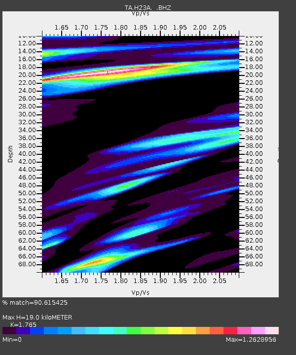
H23A Clabaugh Cattle Company, Gillette, WY, USA - Earthquake Result Viewer
| Earthquake location: |
East Of Kuril Islands |
| Earthquake latitude/longitude: |
46.9/155.2 |
| Earthquake time(UTC): |
2009/01/15 (015) 17:49:39 GMT |
| Earthquake Depth: |
36 km |
| Earthquake Magnitude: |
6.9 MB, 7.5 MS, 7.4 MW, 7.4 MW |
| Earthquake Catalog/Contributor: |
WHDF/NEIC |
|
| Network: |
TA USArray Transportable Network (new EarthScope stations) |
| Station: |
H23A Clabaugh Cattle Company, Gillette, WY, USA |
| Lat/Lon: |
44.56 N/105.40 W |
| Elevation: |
1213 m |
|
| Distance: |
64.7 deg |
| Az: |
51.286 deg |
| Baz: |
311.489 deg |
| Ray Param: |
0.058725115 |
| Estimated Moho Depth: |
19.0 km |
| Estimated Crust Vp/Vs: |
1.76 |
| Assumed Crust Vp: |
6.242 km/s |
| Estimated Crust Vs: |
3.537 km/s |
| Estimated Crust Poisson's Ratio: |
0.26 |
|
| Radial Match: |
90.615425 % |
| Radial Bump: |
339 |
| Transverse Match: |
78.11196 % |
| Transverse Bump: |
400 |
| SOD ConfigId: |
2834 |
| Insert Time: |
2010-03-06 11:48:01.239 +0000 |
| GWidth: |
2.5 |
| Max Bumps: |
400 |
| Tol: |
0.001 |
|

Signal To Noise
| Channel | StoN | STA | LTA |
| TA:H23A: :BHZ:20090115T17:59:42.374016Z | 21.274565 | 1.2378215E-5 | 5.8183167E-7 |
| TA:H23A: :BHN:20090115T17:59:42.374016Z | 1.1500503 | 3.551398E-6 | 3.0880374E-6 |
| TA:H23A: :BHE:20090115T17:59:42.374016Z | 5.2691827 | 6.062533E-6 | 1.1505642E-6 |
| Arrivals |
| Ps | 2.4 SECOND |
| PpPs | 8.1 SECOND |
| PsPs/PpSs | 11 SECOND |


