You are here: Home > Network List > TA - USArray Transportable Network (new EarthScope stations) Stations List
> Station H23A Clabaugh Cattle Company, Gillette, WY, USA > Earthquake Result Viewer
H23A Clabaugh Cattle Company, Gillette, WY, USA - Earthquake Result Viewer
| Earthquake location: |
Norwegian Sea |
| Earthquake latitude/longitude: |
72.2/0.9 |
| Earthquake time(UTC): |
2009/08/20 (232) 06:35:04 GMT |
| Earthquake Depth: |
6.0 km |
| Earthquake Magnitude: |
5.9 MB, 5.7 MS, 6.0 MW, 6.0 MW |
| Earthquake Catalog/Contributor: |
WHDF/NEIC |
|
| Network: |
TA USArray Transportable Network (new EarthScope stations) |
| Station: |
H23A Clabaugh Cattle Company, Gillette, WY, USA |
| Lat/Lon: |
44.56 N/105.40 W |
| Elevation: |
1213 m |
|
| Distance: |
52.9 deg |
| Az: |
300.651 deg |
| Baz: |
21.724 deg |
| Ray Param: |
0.06648577 |
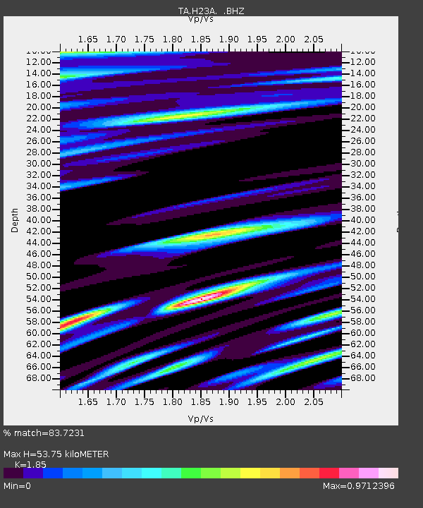
| Estimated Moho Depth: |
53.75 km |
| Estimated Crust Vp/Vs: |
1.85 |
| Assumed Crust Vp: |
6.242 km/s |
| Estimated Crust Vs: |
3.374 km/s |
| Estimated Crust Poisson's Ratio: |
0.29 |
|
| Radial Match: |
83.7231 % |
| Radial Bump: |
400 |
| Transverse Match: |
71.886635 % |
| Transverse Bump: |
400 |
| SOD ConfigId: |
2622 |
| Insert Time: |
2010-03-06 11:48:06.056 +0000 |
| GWidth: |
2.5 |
| Max Bumps: |
400 |
| Tol: |
0.001 |
|

Signal To Noise
| Channel | StoN | STA | LTA |
| TA:H23A: :BHZ:20090820T06:43:49.95002Z | 12.457607 | 1.329566E-6 | 1.0672724E-7 |
| TA:H23A: :BHN:20090820T06:43:49.95002Z | 2.1775935 | 4.374577E-7 | 2.0089044E-7 |
| TA:H23A: :BHE:20090820T06:43:49.95002Z | 1.2020622 | 2.0812908E-7 | 1.7314333E-7 |
| Arrivals |
| Ps | 7.7 SECOND |
| PpPs | 23 SECOND |
| PsPs/PpSs | 31 SECOND |


