You are here: Home > Network List > TA - USArray Transportable Network (new EarthScope stations) Stations List
> Station H23A Clabaugh Cattle Company, Gillette, WY, USA > Earthquake Result Viewer
H23A Clabaugh Cattle Company, Gillette, WY, USA - Earthquake Result Viewer
| Earthquake location: |
Southern Peru |
| Earthquake latitude/longitude: |
-15.0/-70.4 |
| Earthquake time(UTC): |
2009/07/12 (193) 06:12:47 GMT |
| Earthquake Depth: |
199 km |
| Earthquake Magnitude: |
5.7 MB, 6.1 MW, 6.1 MW |
| Earthquake Catalog/Contributor: |
WHDF/NEIC |
|
| Network: |
TA USArray Transportable Network (new EarthScope stations) |
| Station: |
H23A Clabaugh Cattle Company, Gillette, WY, USA |
| Lat/Lon: |
44.56 N/105.40 W |
| Elevation: |
1213 m |
|
| Distance: |
67.3 deg |
| Az: |
333.646 deg |
| Baz: |
143.13 deg |
| Ray Param: |
0.056467853 |
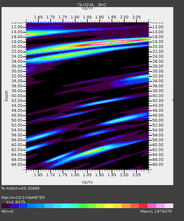
| Estimated Moho Depth: |
18.0 km |
| Estimated Crust Vp/Vs: |
1.95 |
| Assumed Crust Vp: |
6.242 km/s |
| Estimated Crust Vs: |
3.205 km/s |
| Estimated Crust Poisson's Ratio: |
0.32 |
|
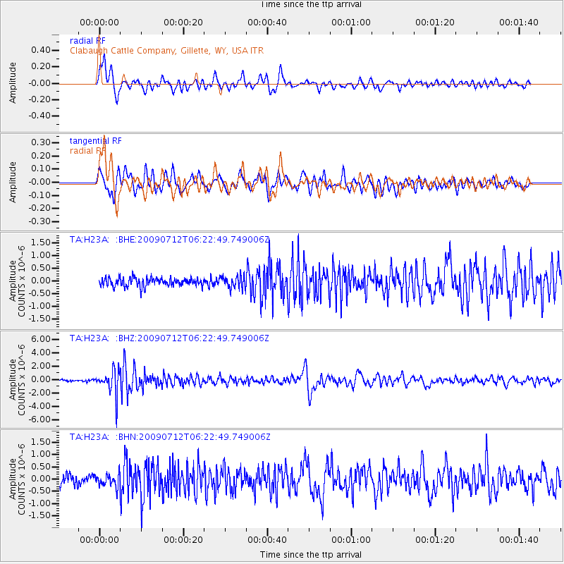
| Radial Match: |
84.30669 % |
| Radial Bump: |
400 |
| Transverse Match: |
75.23566 % |
| Transverse Bump: |
400 |
| SOD ConfigId: |
2648 |
| Insert Time: |
2010-03-06 11:48:23.783 +0000 |
| GWidth: |
2.5 |
| Max Bumps: |
400 |
| Tol: |
0.001 |
|
Signal To Noise
| Channel | StoN | STA | LTA |
| TA:H23A: :BHZ:20090712T06:22:49.749006Z | 16.307009 | 1.8396962E-6 | 1.12816295E-7 |
| TA:H23A: :BHN:20090712T06:22:49.749006Z | 1.2762653 | 2.5194208E-7 | 1.9740574E-7 |
| TA:H23A: :BHE:20090712T06:22:49.749006Z | 1.424768 | 2.3067435E-7 | 1.6190309E-7 |
| Arrivals |
| Ps | 2.8 SECOND |
| PpPs | 8.2 SECOND |
| PsPs/PpSs | 11 SECOND |


