You are here: Home > Network List > TA - USArray Transportable Network (new EarthScope stations) Stations List
> Station H23A Clabaugh Cattle Company, Gillette, WY, USA > Earthquake Result Viewer
H23A Clabaugh Cattle Company, Gillette, WY, USA - Earthquake Result Viewer
| Earthquake location: |
Kuril Islands |
| Earthquake latitude/longitude: |
46.0/151.5 |
| Earthquake time(UTC): |
2009/04/07 (097) 04:23:33 GMT |
| Earthquake Depth: |
31 km |
| Earthquake Magnitude: |
6.5 MB, 6.8 MS, 6.9 MW, 6.9 MW |
| Earthquake Catalog/Contributor: |
WHDF/NEIC |
|
| Network: |
TA USArray Transportable Network (new EarthScope stations) |
| Station: |
H23A Clabaugh Cattle Company, Gillette, WY, USA |
| Lat/Lon: |
44.56 N/105.40 W |
| Elevation: |
1213 m |
|
| Distance: |
67.1 deg |
| Az: |
49.117 deg |
| Baz: |
312.558 deg |
| Ray Param: |
0.05714036 |
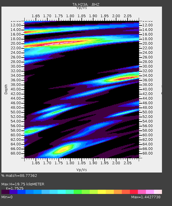
| Estimated Moho Depth: |
19.75 km |
| Estimated Crust Vp/Vs: |
1.75 |
| Assumed Crust Vp: |
6.242 km/s |
| Estimated Crust Vs: |
3.562 km/s |
| Estimated Crust Poisson's Ratio: |
0.26 |
|
| Radial Match: |
88.77362 % |
| Radial Bump: |
400 |
| Transverse Match: |
74.60129 % |
| Transverse Bump: |
400 |
| SOD ConfigId: |
2658 |
| Insert Time: |
2010-03-06 11:48:29.314 +0000 |
| GWidth: |
2.5 |
| Max Bumps: |
400 |
| Tol: |
0.001 |
|

Signal To Noise
| Channel | StoN | STA | LTA |
| TA:H23A: :BHZ:20090407T04:33:52.600012Z | 21.640165 | 5.609888E-6 | 2.5923498E-7 |
| TA:H23A: :BHN:20090407T04:33:52.600012Z | 3.85291 | 1.5011434E-6 | 3.896129E-7 |
| TA:H23A: :BHE:20090407T04:33:52.600012Z | 4.320855 | 1.9826298E-6 | 4.5885125E-7 |
| Arrivals |
| Ps | 2.5 SECOND |
| PpPs | 8.4 SECOND |
| PsPs/PpSs | 11 SECOND |


