You are here: Home > Network List > TA - USArray Transportable Network (new EarthScope stations) Stations List
> Station H23A Clabaugh Cattle Company, Gillette, WY, USA > Earthquake Result Viewer
H23A Clabaugh Cattle Company, Gillette, WY, USA - Earthquake Result Viewer
| Earthquake location: |
Kuril Islands |
| Earthquake latitude/longitude: |
46.0/151.4 |
| Earthquake time(UTC): |
2009/04/18 (108) 19:17:58 GMT |
| Earthquake Depth: |
35 km |
| Earthquake Magnitude: |
6.3 MB, 6.3 MS, 6.6 MW, 6.4 MW |
| Earthquake Catalog/Contributor: |
WHDF/NEIC |
|
| Network: |
TA USArray Transportable Network (new EarthScope stations) |
| Station: |
H23A Clabaugh Cattle Company, Gillette, WY, USA |
| Lat/Lon: |
44.56 N/105.40 W |
| Elevation: |
1213 m |
|
| Distance: |
67.2 deg |
| Az: |
49.043 deg |
| Baz: |
312.59 deg |
| Ray Param: |
0.057074912 |
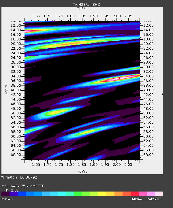
| Estimated Moho Depth: |
34.75 km |
| Estimated Crust Vp/Vs: |
2.01 |
| Assumed Crust Vp: |
6.242 km/s |
| Estimated Crust Vs: |
3.105 km/s |
| Estimated Crust Poisson's Ratio: |
0.34 |
|
| Radial Match: |
86.36792 % |
| Radial Bump: |
400 |
| Transverse Match: |
78.17093 % |
| Transverse Bump: |
400 |
| SOD ConfigId: |
2760 |
| Insert Time: |
2010-03-06 11:48:31.518 +0000 |
| GWidth: |
2.5 |
| Max Bumps: |
400 |
| Tol: |
0.001 |
|
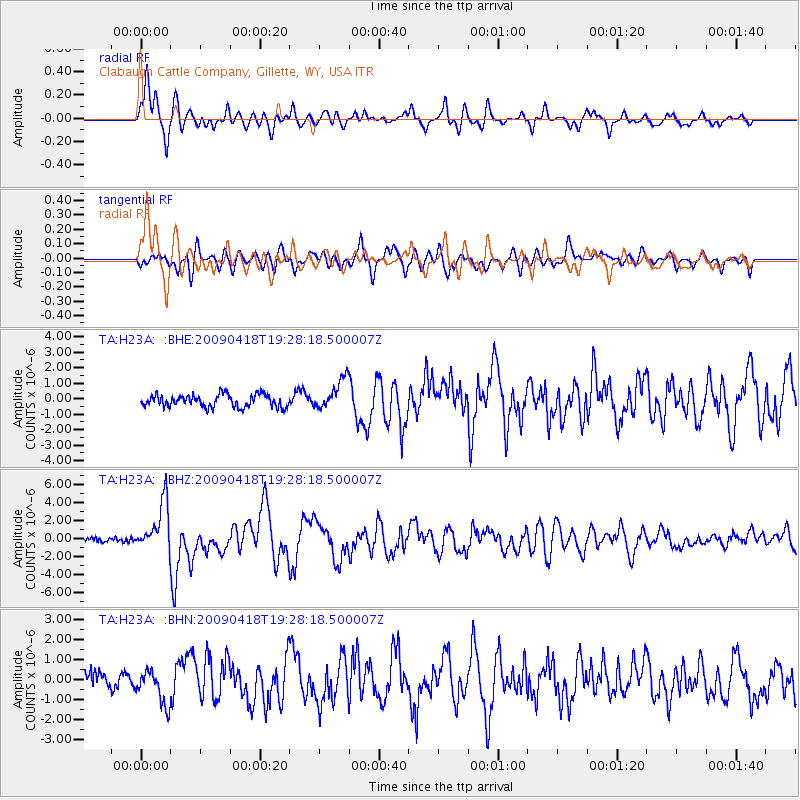
Signal To Noise
| Channel | StoN | STA | LTA |
| TA:H23A: :BHZ:20090418T19:28:18.500007Z | 16.638927 | 2.7132883E-6 | 1.630687E-7 |
| TA:H23A: :BHN:20090418T19:28:18.500007Z | 2.1116235 | 8.500056E-7 | 4.0253656E-7 |
| TA:H23A: :BHE:20090418T19:28:18.500007Z | 2.5163927 | 9.916848E-7 | 3.9408985E-7 |
| Arrivals |
| Ps | 5.8 SECOND |
| PpPs | 16 SECOND |
| PsPs/PpSs | 22 SECOND |


