You are here: Home > Network List > TA - USArray Transportable Network (new EarthScope stations) Stations List
> Station G21K Allakaket, AK, USA > Earthquake Result Viewer
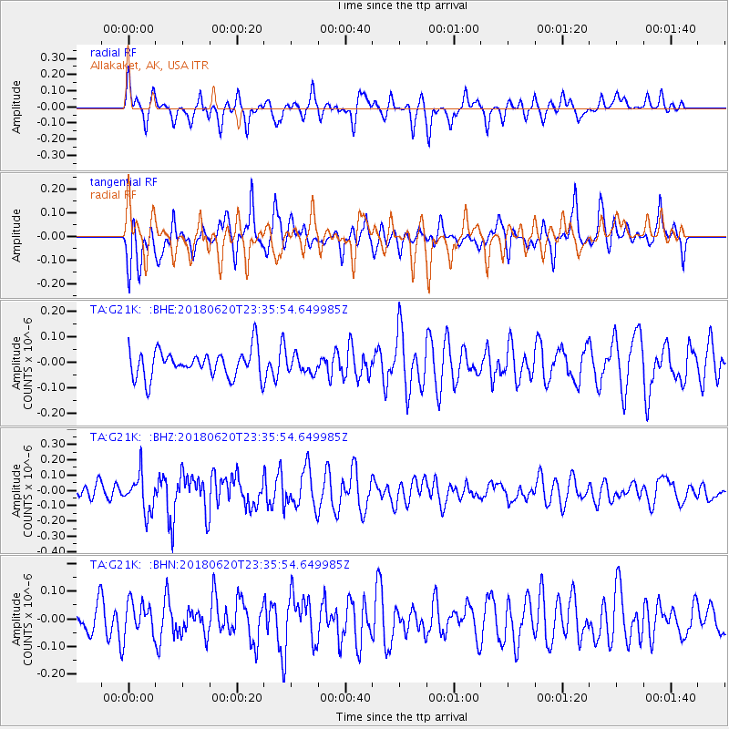
G21K Allakaket, AK, USA - Earthquake Result Viewer
*The percent match for this event was below the threshold and hence no stack was calculated.
| Earthquake location: |
Tonga Islands Region |
| Earthquake latitude/longitude: |
-22.4/-175.1 |
| Earthquake time(UTC): |
2018/06/20 (171) 23:23:26 GMT |
| Earthquake Depth: |
14 km |
| Earthquake Magnitude: |
5.4 Mww |
| Earthquake Catalog/Contributor: |
NEIC PDE/us |
|
| Network: |
TA USArray Transportable Network (new EarthScope stations) |
| Station: |
G21K Allakaket, AK, USA |
| Lat/Lon: |
66.52 N/153.51 W |
| Elevation: |
446 m |
|
| Distance: |
90.1 deg |
| Az: |
8.473 deg |
| Baz: |
199.895 deg |
| Ray Param: |
$rayparam |
*The percent match for this event was below the threshold and hence was not used in the summary stack. |
|
| Radial Match: |
48.588444 % |
| Radial Bump: |
330 |
| Transverse Match: |
51.677002 % |
| Transverse Bump: |
376 |
| SOD ConfigId: |
13570011 |
| Insert Time: |
2019-04-30 10:05:53.600 +0000 |
| GWidth: |
2.5 |
| Max Bumps: |
400 |
| Tol: |
0.001 |
|
Signal To Noise
| Channel | StoN | STA | LTA |
| TA:G21K: :BHZ:20180620T23:35:54.649985Z | 2.5450284 | 1.2225038E-7 | 4.8034977E-8 |
| TA:G21K: :BHN:20180620T23:35:54.649985Z | 1.2552489 | 5.8804137E-8 | 4.6846594E-8 |
| TA:G21K: :BHE:20180620T23:35:54.649985Z | 0.6102324 | 3.2659663E-8 | 5.3520044E-8 |
| Arrivals |
| Ps | |
| PpPs | |
| PsPs/PpSs | |


