You are here: Home > Network List > TA - USArray Transportable Network (new EarthScope stations) Stations List
> Station O17K Koliganek, Bristol Bay, AK, USA > Earthquake Result Viewer
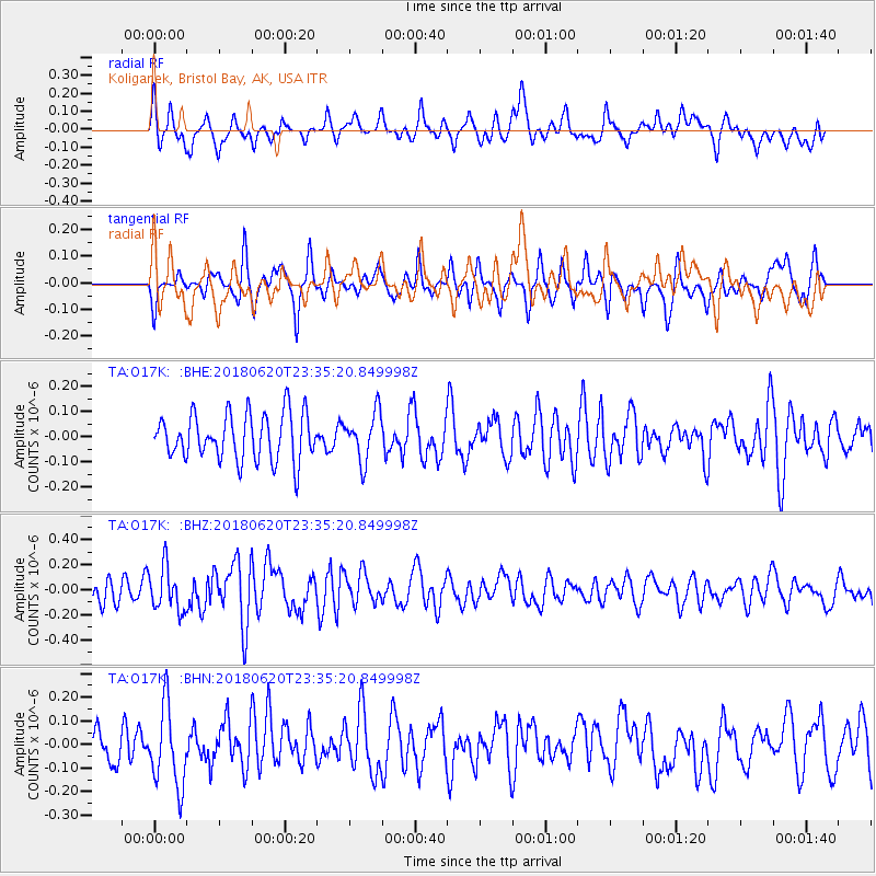
O17K Koliganek, Bristol Bay, AK, USA - Earthquake Result Viewer
*The percent match for this event was below the threshold and hence no stack was calculated.
| Earthquake location: |
Tonga Islands Region |
| Earthquake latitude/longitude: |
-22.4/-175.1 |
| Earthquake time(UTC): |
2018/06/20 (171) 23:23:26 GMT |
| Earthquake Depth: |
14 km |
| Earthquake Magnitude: |
5.4 Mww |
| Earthquake Catalog/Contributor: |
NEIC PDE/us |
|
| Network: |
TA USArray Transportable Network (new EarthScope stations) |
| Station: |
O17K Koliganek, Bristol Bay, AK, USA |
| Lat/Lon: |
59.77 N/157.09 W |
| Elevation: |
156 m |
|
| Distance: |
83.2 deg |
| Az: |
9.051 deg |
| Baz: |
196.726 deg |
| Ray Param: |
$rayparam |
*The percent match for this event was below the threshold and hence was not used in the summary stack. |
|
| Radial Match: |
57.863487 % |
| Radial Bump: |
400 |
| Transverse Match: |
47.44901 % |
| Transverse Bump: |
310 |
| SOD ConfigId: |
13570011 |
| Insert Time: |
2019-04-30 10:06:41.330 +0000 |
| GWidth: |
2.5 |
| Max Bumps: |
400 |
| Tol: |
0.001 |
|
Signal To Noise
| Channel | StoN | STA | LTA |
| TA:O17K: :BHZ:20180620T23:35:20.849998Z | 1.8380506 | 1.7352122E-7 | 9.4405024E-8 |
| TA:O17K: :BHN:20180620T23:35:20.849998Z | 2.0363786 | 1.707048E-7 | 8.382763E-8 |
| TA:O17K: :BHE:20180620T23:35:20.849998Z | 1.0253743 | 9.440114E-8 | 9.206505E-8 |
| Arrivals |
| Ps | |
| PpPs | |
| PsPs/PpSs | |


