You are here: Home > Network List > IU - Global Seismograph Network (GSN - IRIS/USGS) Stations List
> Station POHA Pohakuloa, Hawaii, USA > Earthquake Result Viewer
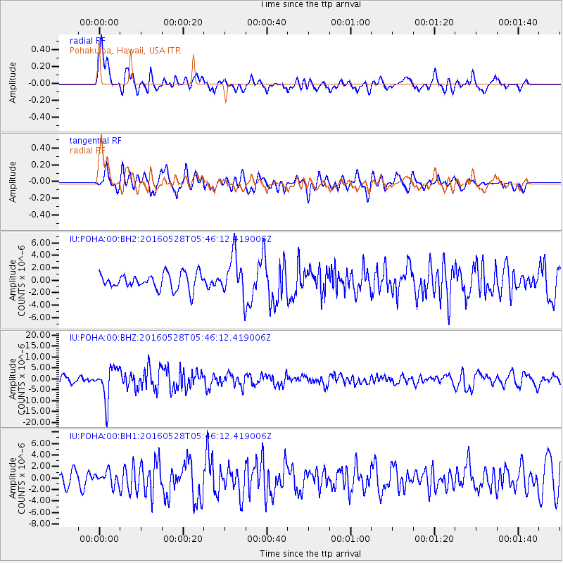
POHA Pohakuloa, Hawaii, USA - Earthquake Result Viewer
*The percent match for this event was below the threshold and hence no stack was calculated.
| Earthquake location: |
South Of Fiji Islands |
| Earthquake latitude/longitude: |
-22.0/-178.2 |
| Earthquake time(UTC): |
2016/05/28 (149) 05:38:51 GMT |
| Earthquake Depth: |
417 km |
| Earthquake Magnitude: |
6.6 MO |
| Earthquake Catalog/Contributor: |
NEIC PDE/NEIC ALERT |
|
| Network: |
IU Global Seismograph Network (GSN - IRIS/USGS) |
| Station: |
POHA Pohakuloa, Hawaii, USA |
| Lat/Lon: |
19.76 N/155.53 W |
| Elevation: |
1990 m |
|
| Distance: |
47.0 deg |
| Az: |
29.677 deg |
| Baz: |
209.195 deg |
| Ray Param: |
$rayparam |
*The percent match for this event was below the threshold and hence was not used in the summary stack. |
|
| Radial Match: |
79.283966 % |
| Radial Bump: |
400 |
| Transverse Match: |
70.16618 % |
| Transverse Bump: |
400 |
| SOD ConfigId: |
1475611 |
| Insert Time: |
2016-06-11 05:43:31.639 +0000 |
| GWidth: |
2.5 |
| Max Bumps: |
400 |
| Tol: |
0.001 |
|
Signal To Noise
| Channel | StoN | STA | LTA |
| IU:POHA:00:BHZ:20160528T05:46:12.419006Z | 5.870105 | 7.740014E-6 | 1.3185478E-6 |
| IU:POHA:00:BH1:20160528T05:46:12.419006Z | 0.8809962 | 1.2331332E-6 | 1.3997031E-6 |
| IU:POHA:00:BH2:20160528T05:46:12.419006Z | 2.6468608 | 3.3593108E-6 | 1.2691678E-6 |
| Arrivals |
| Ps | |
| PpPs | |
| PsPs/PpSs | |


