You are here: Home > Network List > TA - USArray Transportable Network (new EarthScope stations) Stations List
> Station H23A Clabaugh Cattle Company, Gillette, WY, USA > Earthquake Result Viewer
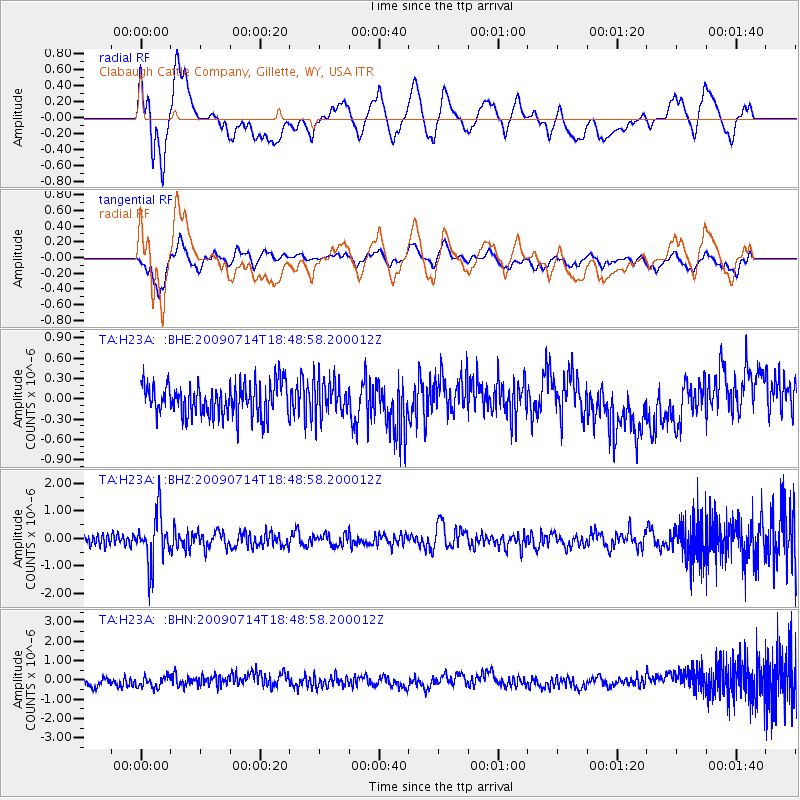
H23A Clabaugh Cattle Company, Gillette, WY, USA - Earthquake Result Viewer
*The percent match for this event was below the threshold and hence no stack was calculated.
| Earthquake location: |
Chile-Bolivia Border Region |
| Earthquake latitude/longitude: |
-21.8/-67.1 |
| Earthquake time(UTC): |
2009/07/14 (195) 18:38:08 GMT |
| Earthquake Depth: |
176 km |
| Earthquake Magnitude: |
5.7 MW, 5.4 MB, 5.7 MW |
| Earthquake Catalog/Contributor: |
WHDF/NEIC |
|
| Network: |
TA USArray Transportable Network (new EarthScope stations) |
| Station: |
H23A Clabaugh Cattle Company, Gillette, WY, USA |
| Lat/Lon: |
44.56 N/105.40 W |
| Elevation: |
1213 m |
|
| Distance: |
74.8 deg |
| Az: |
332.657 deg |
| Baz: |
143.341 deg |
| Ray Param: |
$rayparam |
*The percent match for this event was below the threshold and hence was not used in the summary stack. |
|
| Radial Match: |
57.918606 % |
| Radial Bump: |
400 |
| Transverse Match: |
61.225487 % |
| Transverse Bump: |
400 |
| SOD ConfigId: |
2648 |
| Insert Time: |
2010-03-06 11:50:07.395 +0000 |
| GWidth: |
2.5 |
| Max Bumps: |
400 |
| Tol: |
0.001 |
|
Signal To Noise
| Channel | StoN | STA | LTA |
| TA:H23A: :BHZ:20090714T18:48:58.200012Z | 6.1361494 | 8.9049104E-7 | 1.4512212E-7 |
| TA:H23A: :BHN:20090714T18:48:58.200012Z | 1.2971002 | 2.9176965E-7 | 2.2493997E-7 |
| TA:H23A: :BHE:20090714T18:48:58.200012Z | 1.1186503 | 2.6269495E-7 | 2.3483206E-7 |
| Arrivals |
| Ps | |
| PpPs | |
| PsPs/PpSs | |


