You are here: Home > Network List > TA - USArray Transportable Network (new EarthScope stations) Stations List
> Station D17A Six Diamond Ranch, Ranyesford, MT, USA > Earthquake Result Viewer
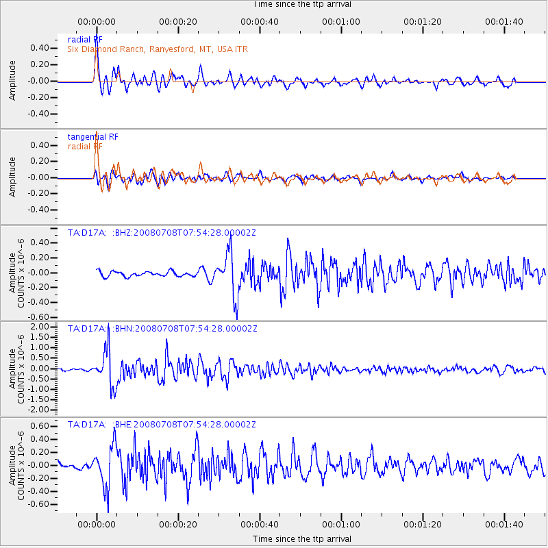
D17A Six Diamond Ranch, Ranyesford, MT, USA - Earthquake Result Viewer

| Earthquake location: |
Ryukyu Islands, Japan |
| Earthquake latitude/longitude: |
27.5/128.3 |
| Earthquake time(UTC): |
2008/07/08 (190) 07:42:10 GMT |
| Earthquake Depth: |
43 km |
| Earthquake Magnitude: |
6.0 MB, 5.5 MS, 6.0 MW, 6.0 MW |
| Earthquake Catalog/Contributor: |
WHDF/NEIC |
|
| Network: |
TA USArray Transportable Network (new EarthScope stations) |
| Station: |
D17A Six Diamond Ranch, Ranyesford, MT, USA |
| Lat/Lon: |
47.15 N/110.69 W |
| Elevation: |
1535 m |
|
| Distance: |
88.6 deg |
| Az: |
35.826 deg |
| Baz: |
310.397 deg |
| Ray Param: |
0.04238591 |
| Estimated Moho Depth: |
43.25 km |
| Estimated Crust Vp/Vs: |
1.76 |
| Assumed Crust Vp: |
6.306 km/s |
| Estimated Crust Vs: |
3.573 km/s |
| Estimated Crust Poisson's Ratio: |
0.26 |
|
| Radial Match: |
89.81143 % |
| Radial Bump: |
400 |
| Transverse Match: |
80.19211 % |
| Transverse Bump: |
400 |
| SOD ConfigId: |
2504 |
| Insert Time: |
2010-03-06 11:50:18.932 +0000 |
| GWidth: |
2.5 |
| Max Bumps: |
400 |
| Tol: |
0.001 |
|
Signal To Noise
| Channel | StoN | STA | LTA |
| TA:D17A: :BHN:20080708T07:54:28.00002Z | 23.033363 | 8.9121687E-7 | 3.8692434E-8 |
| TA:D17A: :BHE:20080708T07:54:28.00002Z | 6.5422363 | 3.276864E-7 | 5.0087827E-8 |
| TA:D17A: :BHZ:20080708T07:54:28.00002Z | 8.94035 | 2.9467438E-7 | 3.2960052E-8 |
| Arrivals |
| Ps | 5.4 SECOND |
| PpPs | 19 SECOND |
| PsPs/PpSs | 24 SECOND |


