You are here: Home > Network List > TA - USArray Transportable Network (new EarthScope stations) Stations List
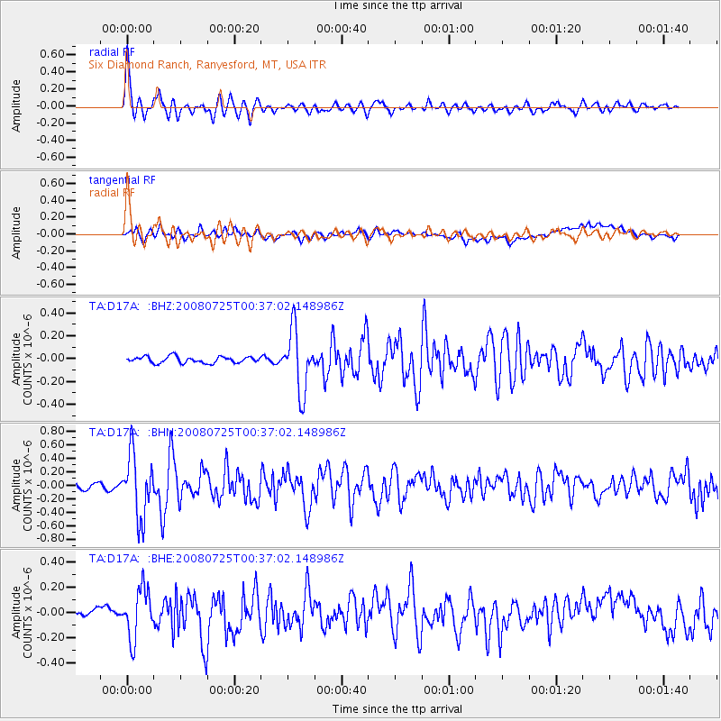
> Station D17A Six Diamond Ranch, Ranyesford, MT, USA > Earthquake Result Viewer
D17A Six Diamond Ranch, Ranyesford, MT, USA - Earthquake Result Viewer
| Earthquake location: |
Rat Islands, Aleutian Islands |
| Earthquake latitude/longitude: |
51.3/179.0 |
| Earthquake time(UTC): |
2008/07/25 (207) 00:29:22 GMT |
| Earthquake Depth: |
21 km |
| Earthquake Magnitude: |
5.7 MB, 5.5 MS, 5.9 MW, 5.9 MW |
| Earthquake Catalog/Contributor: |
WHDF/NEIC |
|
| Network: |
TA USArray Transportable Network (new EarthScope stations) |
| Station: |
D17A Six Diamond Ranch, Ranyesford, MT, USA |
| Lat/Lon: |
47.15 N/110.69 W |
| Elevation: |
1535 m |
|
| Distance: |
44.5 deg |
| Az: |
66.436 deg |
| Baz: |
302.485 deg |
| Ray Param: |
0.071838275 |
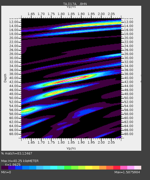
| Estimated Moho Depth: |
40.25 km |
| Estimated Crust Vp/Vs: |
1.86 |
| Assumed Crust Vp: |
6.306 km/s |
| Estimated Crust Vs: |
3.386 km/s |
| Estimated Crust Poisson's Ratio: |
0.30 |
|
| Radial Match: |
83.12467 % |
| Radial Bump: |
400 |
| Transverse Match: |
60.57344 % |
| Transverse Bump: |
400 |
| SOD ConfigId: |
2504 |
| Insert Time: |
2010-03-06 11:50:29.387 +0000 |
| GWidth: |
2.5 |
| Max Bumps: |
400 |
| Tol: |
0.001 |
|
Signal To Noise
| Channel | StoN | STA | LTA |
| TA:D17A: :BHN:20080725T00:37:02.148986Z | 9.566031 | 4.6571967E-7 | 4.8684733E-8 |
| TA:D17A: :BHE:20080725T00:37:02.148986Z | 4.3498216 | 1.9927052E-7 | 4.581119E-8 |
| TA:D17A: :BHZ:20080725T00:37:02.148986Z | 9.6547785 | 2.6957764E-7 | 2.7921681E-8 |
| Arrivals |
| Ps | 5.8 SECOND |
| PpPs | 17 SECOND |
| PsPs/PpSs | 23 SECOND |


