You are here: Home > Network List > TA - USArray Transportable Network (new EarthScope stations) Stations List
> Station TOLK Toolik Lake Research Station, AK, USA > Earthquake Result Viewer
TOLK Toolik Lake Research Station, AK, USA - Earthquake Result Viewer
| Earthquake location: |
South Of Fiji Islands |
| Earthquake latitude/longitude: |
-22.0/-178.2 |
| Earthquake time(UTC): |
2016/05/28 (149) 05:38:51 GMT |
| Earthquake Depth: |
417 km |
| Earthquake Magnitude: |
6.6 MO |
| Earthquake Catalog/Contributor: |
NEIC PDE/NEIC ALERT |
|
| Network: |
TA USArray Transportable Network (new EarthScope stations) |
| Station: |
TOLK Toolik Lake Research Station, AK, USA |
| Lat/Lon: |
68.64 N/149.57 W |
| Elevation: |
760 m |
|
| Distance: |
92.8 deg |
| Az: |
10.108 deg |
| Baz: |
206.394 deg |
| Ray Param: |
0.04109763 |
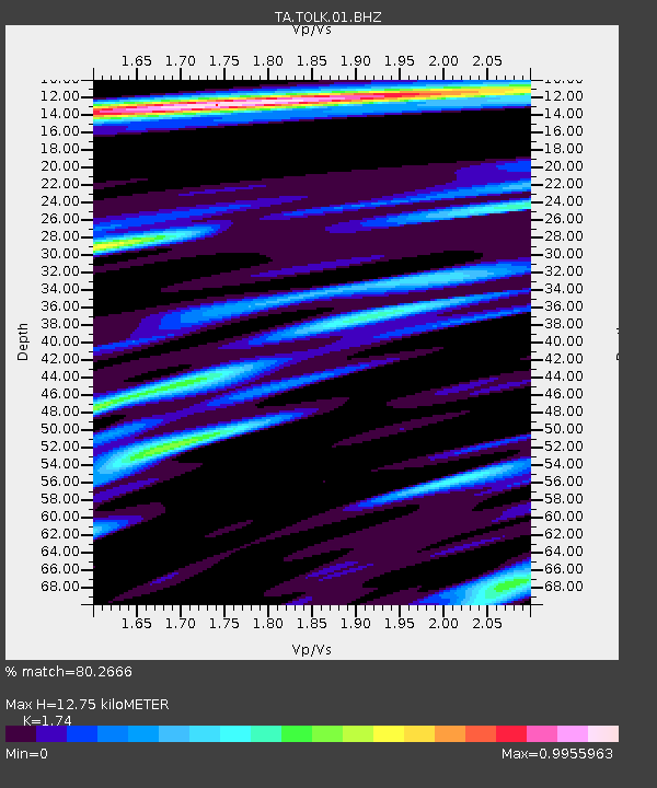
| Estimated Moho Depth: |
12.75 km |
| Estimated Crust Vp/Vs: |
1.74 |
| Assumed Crust Vp: |
6.316 km/s |
| Estimated Crust Vs: |
3.63 km/s |
| Estimated Crust Poisson's Ratio: |
0.25 |
|
| Radial Match: |
80.2666 % |
| Radial Bump: |
400 |
| Transverse Match: |
73.743996 % |
| Transverse Bump: |
400 |
| SOD ConfigId: |
1475611 |
| Insert Time: |
2016-06-11 05:45:00.329 +0000 |
| GWidth: |
2.5 |
| Max Bumps: |
400 |
| Tol: |
0.001 |
|
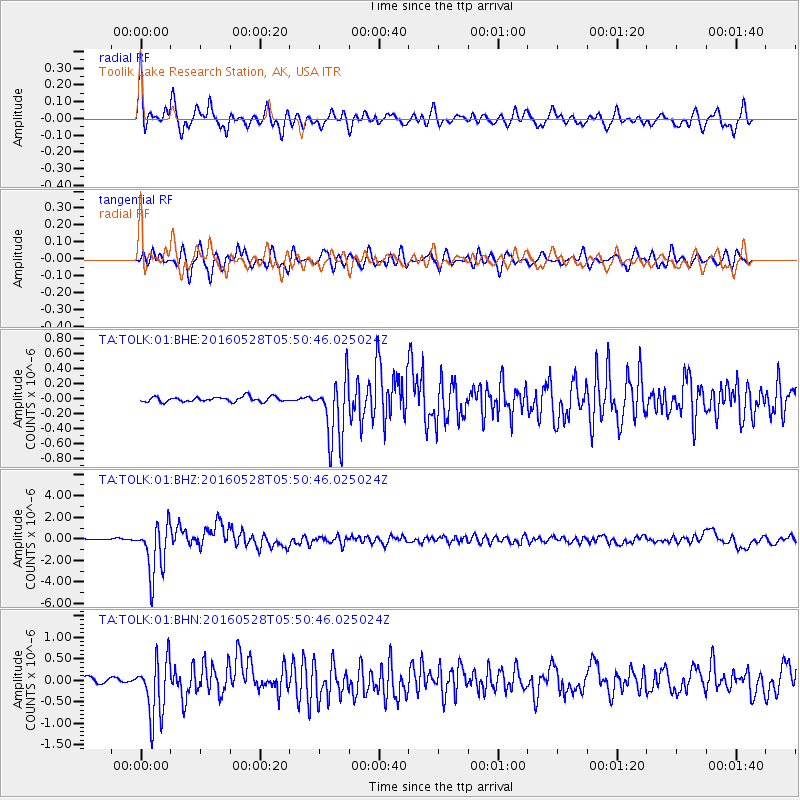
Signal To Noise
| Channel | StoN | STA | LTA |
| TA:TOLK:01:BHZ:20160528T05:50:46.025024Z | 37.045906 | 2.3855516E-6 | 6.439447E-8 |
| TA:TOLK:01:BHN:20160528T05:50:46.025024Z | 14.48241 | 6.834468E-7 | 4.7191506E-8 |
| TA:TOLK:01:BHE:20160528T05:50:46.025024Z | 13.204927 | 4.323815E-7 | 3.274395E-8 |
| Arrivals |
| Ps | 1.5 SECOND |
| PpPs | 5.4 SECOND |
| PsPs/PpSs | 6.9 SECOND |


