You are here: Home > Network List > CI - Caltech Regional Seismic Network Stations List
> Station ADO Adelanto Receiving Station, Victorville, CA, USA > Earthquake Result Viewer
ADO Adelanto Receiving Station, Victorville, CA, USA - Earthquake Result Viewer
| Earthquake location: |
Andreanof Islands, Aleutian Is. |
| Earthquake latitude/longitude: |
51.9/-179.2 |
| Earthquake time(UTC): |
2008/04/16 (107) 05:54:19 GMT |
| Earthquake Depth: |
13 km |
| Earthquake Magnitude: |
6.1 MB, 6.5 MS, 6.6 MW, 6.6 MW |
| Earthquake Catalog/Contributor: |
WHDF/NEIC |
|
| Network: |
CI Caltech Regional Seismic Network |
| Station: |
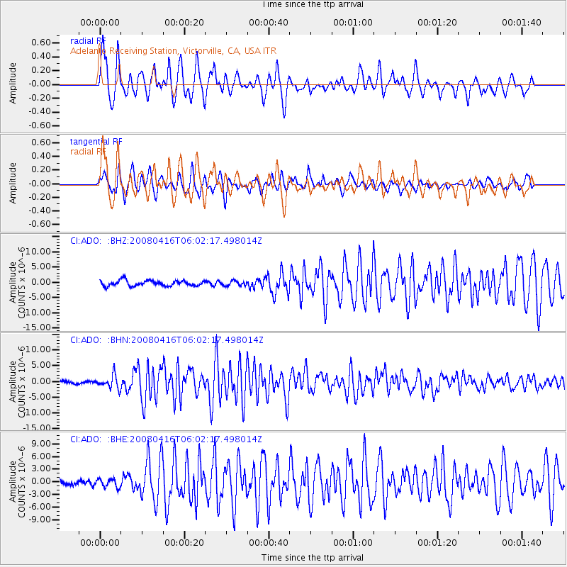
ADO Adelanto Receiving Station, Victorville, CA, USA |
| Lat/Lon: |
34.55 N/117.43 W |
| Elevation: |
908 m |
|
| Distance: |
46.7 deg |
| Az: |
86.598 deg |
| Baz: |
311.435 deg |
| Ray Param: |
0.07044726 |
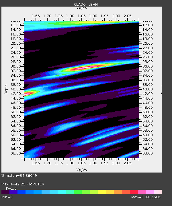
| Estimated Moho Depth: |
42.25 km |
| Estimated Crust Vp/Vs: |
1.60 |
| Assumed Crust Vp: |
6.276 km/s |
| Estimated Crust Vs: |
3.922 km/s |
| Estimated Crust Poisson's Ratio: |
0.18 |
|
| Radial Match: |
84.36049 % |
| Radial Bump: |
400 |
| Transverse Match: |
87.49148 % |
| Transverse Bump: |
400 |
| SOD ConfigId: |
2504 |
| Insert Time: |
2010-02-26 02:01:03.664 +0000 |
| GWidth: |
2.5 |
| Max Bumps: |
400 |
| Tol: |
0.001 |
|
Signal To Noise
| Channel | StoN | STA | LTA |
| CI:ADO: :BHN:20080416T06:02:17.498014Z | 2.8866827 | 2.0626458E-6 | 7.145385E-7 |
| CI:ADO: :BHE:20080416T06:02:17.498014Z | 1.584824 | 1.0190131E-6 | 6.429819E-7 |
| CI:ADO: :BHZ:20080416T06:02:17.498014Z | 0.85487556 | 7.681816E-7 | 8.9858884E-7 |
| Arrivals |
| Ps | 4.3 SECOND |
| PpPs | 16 SECOND |
| PsPs/PpSs | 21 SECOND |


