You are here: Home > Network List > TA - USArray Transportable Network (new EarthScope stations) Stations List
> Station D17A Six Diamond Ranch, Ranyesford, MT, USA > Earthquake Result Viewer
D17A Six Diamond Ranch, Ranyesford, MT, USA - Earthquake Result Viewer
| Earthquake location: |
Near East Coast Of Honshu, Japan |
| Earthquake latitude/longitude: |
35.5/140.9 |
| Earthquake time(UTC): |
2009/06/06 (157) 05:52:43 GMT |
| Earthquake Depth: |
34 km |
| Earthquake Magnitude: |
5.8 MB, 5.4 MS, 5.8 MW, 5.7 MW |
| Earthquake Catalog/Contributor: |
WHDF/NEIC |
|
| Network: |
TA USArray Transportable Network (new EarthScope stations) |
| Station: |
D17A Six Diamond Ranch, Ranyesford, MT, USA |
| Lat/Lon: |
47.15 N/110.69 W |
| Elevation: |
1535 m |
|
| Distance: |
75.7 deg |
| Az: |
41.932 deg |
| Baz: |
306.958 deg |
| Ray Param: |
0.051424656 |
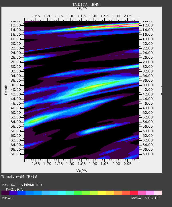
| Estimated Moho Depth: |
11.5 km |
| Estimated Crust Vp/Vs: |
2.10 |
| Assumed Crust Vp: |
6.306 km/s |
| Estimated Crust Vs: |
3.006 km/s |
| Estimated Crust Poisson's Ratio: |
0.35 |
|
| Radial Match: |
84.79718 % |
| Radial Bump: |
400 |
| Transverse Match: |
80.12944 % |
| Transverse Bump: |
400 |
| SOD ConfigId: |
2648 |
| Insert Time: |
2010-03-06 11:51:26.497 +0000 |
| GWidth: |
2.5 |
| Max Bumps: |
400 |
| Tol: |
0.001 |
|

Signal To Noise
| Channel | StoN | STA | LTA |
| TA:D17A: :BHN:20090606T06:03:54.425Z | 7.878918 | 4.782737E-7 | 6.0702966E-8 |
| TA:D17A: :BHE:20090606T06:03:54.425Z | 3.444201 | 1.5117269E-7 | 4.3891948E-8 |
| TA:D17A: :BHZ:20090606T06:03:54.425Z | 4.615174 | 1.9217435E-7 | 4.163968E-8 |
| Arrivals |
| Ps | 2.1 SECOND |
| PpPs | 5.5 SECOND |
| PsPs/PpSs | 7.6 SECOND |


