You are here: Home > Network List > TA - USArray Transportable Network (new EarthScope stations) Stations List
> Station MDND Maddock, ND, USA > Earthquake Result Viewer
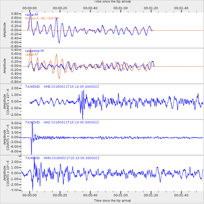
MDND Maddock, ND, USA - Earthquake Result Viewer
*The percent match for this event was below the threshold and hence no stack was calculated.
| Earthquake location: |
Chile-Argentina Border Region |
| Earthquake latitude/longitude: |
-24.3/-67.1 |
| Earthquake time(UTC): |
2018/06/21 (172) 16:08:02 GMT |
| Earthquake Depth: |
175 km |
| Earthquake Magnitude: |
5.7 Mww |
| Earthquake Catalog/Contributor: |
NEIC PDE/us |
|
| Network: |
TA USArray Transportable Network (new EarthScope stations) |
| Station: |
MDND Maddock, ND, USA |
| Lat/Lon: |
47.85 N/99.60 W |
| Elevation: |
479 m |
|
| Distance: |
77.6 deg |
| Az: |
338.223 deg |
| Baz: |
149.835 deg |
| Ray Param: |
$rayparam |
*The percent match for this event was below the threshold and hence was not used in the summary stack. |
|
| Radial Match: |
72.491394 % |
| Radial Bump: |
400 |
| Transverse Match: |
60.762863 % |
| Transverse Bump: |
400 |
| SOD ConfigId: |
13570011 |
| Insert Time: |
2019-04-30 10:17:30.854 +0000 |
| GWidth: |
2.5 |
| Max Bumps: |
400 |
| Tol: |
0.001 |
|
Signal To Noise
| Channel | StoN | STA | LTA |
| TA:MDND: :HHZ:20180621T16:19:06.990002Z | 33.408886 | 3.36266E-6 | 1.0065166E-7 |
| TA:MDND: :HHN:20180621T16:19:06.990002Z | 3.587508 | 1.1145809E-6 | 3.1068387E-7 |
| TA:MDND: :HHE:20180621T16:19:06.990002Z | 2.9327173 | 8.1953743E-7 | 2.7944645E-7 |
| Arrivals |
| Ps | |
| PpPs | |
| PsPs/PpSs | |


