You are here: Home > Network List > TA - USArray Transportable Network (new EarthScope stations) Stations List
> Station TUL3 Leonard, OK, USA > Earthquake Result Viewer
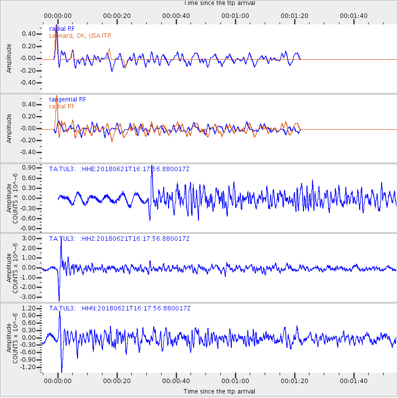
TUL3 Leonard, OK, USA - Earthquake Result Viewer
*The percent match for this event was below the threshold and hence no stack was calculated.
| Earthquake location: |
Chile-Argentina Border Region |
| Earthquake latitude/longitude: |
-24.3/-67.1 |
| Earthquake time(UTC): |
2018/06/21 (172) 16:08:02 GMT |
| Earthquake Depth: |
175 km |
| Earthquake Magnitude: |
5.7 Mww |
| Earthquake Catalog/Contributor: |
NEIC PDE/us |
|
| Network: |
TA USArray Transportable Network (new EarthScope stations) |
| Station: |
TUL3 Leonard, OK, USA |
| Lat/Lon: |
35.91 N/95.79 W |
| Elevation: |
265 m |
|
| Distance: |
65.8 deg |
| Az: |
334.668 deg |
| Baz: |
151.26 deg |
| Ray Param: |
$rayparam |
*The percent match for this event was below the threshold and hence was not used in the summary stack. |
|
| Radial Match: |
77.52184 % |
| Radial Bump: |
370 |
| Transverse Match: |
65.409584 % |
| Transverse Bump: |
389 |
| SOD ConfigId: |
13570011 |
| Insert Time: |
2019-04-30 10:17:43.647 +0000 |
| GWidth: |
2.5 |
| Max Bumps: |
400 |
| Tol: |
0.001 |
|
Signal To Noise
| Channel | StoN | STA | LTA |
| TA:TUL3: :HHZ:20180621T16:17:56.880017Z | 15.023793 | 1.1505268E-6 | 7.6580314E-8 |
| TA:TUL3: :HHN:20180621T16:17:56.880017Z | 7.390437 | 5.012423E-7 | 6.7823095E-8 |
| TA:TUL3: :HHE:20180621T16:17:56.880017Z | 3.1609926 | 3.1489367E-7 | 9.96186E-8 |
| Arrivals |
| Ps | |
| PpPs | |
| PsPs/PpSs | |


