You are here: Home > Network List > TA - USArray Transportable Network (new EarthScope stations) Stations List
> Station D17A Six Diamond Ranch, Ranyesford, MT, USA > Earthquake Result Viewer
D17A Six Diamond Ranch, Ranyesford, MT, USA - Earthquake Result Viewer
| Earthquake location: |
Andreanof Islands, Aleutian Is. |
| Earthquake latitude/longitude: |
51.4/-179.5 |
| Earthquake time(UTC): |
2007/12/19 (353) 09:30:27 GMT |
| Earthquake Depth: |
29 km |
| Earthquake Magnitude: |
6.4 MB, 7.1 MS, 7.1 MW, 7.0 MW |
| Earthquake Catalog/Contributor: |
WHDF/NEIC |
|
| Network: |
TA USArray Transportable Network (new EarthScope stations) |
| Station: |
D17A Six Diamond Ranch, Ranyesford, MT, USA |
| Lat/Lon: |
47.15 N/110.69 W |
| Elevation: |
1535 m |
|
| Distance: |
43.6 deg |
| Az: |
67.3 deg |
| Baz: |
302.066 deg |
| Ray Param: |
0.07237586 |
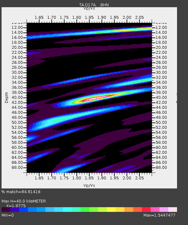
| Estimated Moho Depth: |
40.0 km |
| Estimated Crust Vp/Vs: |
1.88 |
| Assumed Crust Vp: |
6.306 km/s |
| Estimated Crust Vs: |
3.359 km/s |
| Estimated Crust Poisson's Ratio: |
0.30 |
|
| Radial Match: |
94.91416 % |
| Radial Bump: |
374 |
| Transverse Match: |
65.09796 % |
| Transverse Bump: |
400 |
| SOD ConfigId: |
2564 |
| Insert Time: |
2010-03-06 11:51:48.757 +0000 |
| GWidth: |
2.5 |
| Max Bumps: |
400 |
| Tol: |
0.001 |
|

Signal To Noise
| Channel | StoN | STA | LTA |
| TA:D17A: :BHN:20071219T09:37:58.325002Z | 2.6819785 | 1.5660241E-6 | 5.8390634E-7 |
| TA:D17A: :BHE:20071219T09:37:58.325002Z | 5.5406528 | 2.4298033E-6 | 4.3854098E-7 |
| TA:D17A: :BHZ:20071219T09:37:58.325002Z | 5.1400676 | 3.958805E-6 | 7.701854E-7 |
| Arrivals |
| Ps | 5.9 SECOND |
| PpPs | 17 SECOND |
| PsPs/PpSs | 23 SECOND |


