You are here: Home > Network List > TA - USArray Transportable Network (new EarthScope stations) Stations List
> Station D17A Six Diamond Ranch, Ranyesford, MT, USA > Earthquake Result Viewer
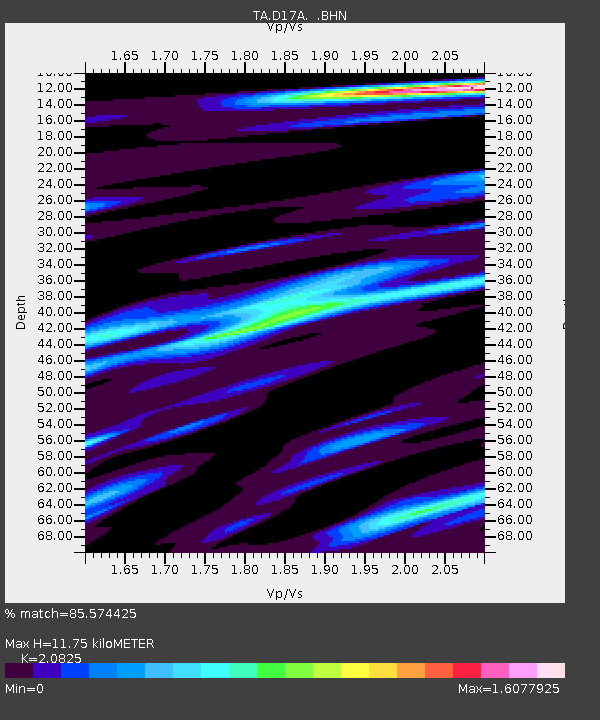
D17A Six Diamond Ranch, Ranyesford, MT, USA - Earthquake Result Viewer
| Earthquake location: |
East Of Kuril Islands |
| Earthquake latitude/longitude: |
46.0/154.2 |
| Earthquake time(UTC): |
2007/10/25 (298) 13:50:02 GMT |
| Earthquake Depth: |
10 km |
| Earthquake Magnitude: |
6.0 MB, 5.7 MS, 6.1 MW, 5.9 MW |
| Earthquake Catalog/Contributor: |
WHDF/NEIC |
|
| Network: |
TA USArray Transportable Network (new EarthScope stations) |
| Station: |
D17A Six Diamond Ranch, Ranyesford, MT, USA |
| Lat/Lon: |
47.15 N/110.69 W |
| Elevation: |
1535 m |
|
| Distance: |
61.2 deg |
| Az: |
50.885 deg |
| Baz: |
307.599 deg |
| Ray Param: |
0.061038237 |
| Estimated Moho Depth: |
11.75 km |
| Estimated Crust Vp/Vs: |
2.08 |
| Assumed Crust Vp: |
6.306 km/s |
| Estimated Crust Vs: |
3.028 km/s |
| Estimated Crust Poisson's Ratio: |
0.35 |
|
| Radial Match: |
85.574425 % |
| Radial Bump: |
307 |
| Transverse Match: |
68.522575 % |
| Transverse Bump: |
400 |
| SOD ConfigId: |
2564 |
| Insert Time: |
2010-03-06 11:52:01.155 +0000 |
| GWidth: |
2.5 |
| Max Bumps: |
400 |
| Tol: |
0.001 |
|

Signal To Noise
| Channel | StoN | STA | LTA |
| TA:D17A: :BHN:20071025T13:59:46.250005Z | 2.1379974 | 2.4812928E-7 | 1.16056874E-7 |
| TA:D17A: :BHE:20071025T13:59:46.250005Z | 3.1076615 | 3.006932E-7 | 9.675867E-8 |
| TA:D17A: :BHZ:20071025T13:59:46.250005Z | 6.1689625 | 5.604231E-7 | 9.0845596E-8 |
| Arrivals |
| Ps | 2.1 SECOND |
| PpPs | 5.5 SECOND |
| PsPs/PpSs | 7.6 SECOND |


