You are here: Home > Network List > UW - Pacific Northwest Regional Seismic Network Stations List
> Station UMAT Pilot Rock, OR, USA > Earthquake Result Viewer
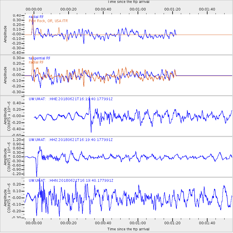
UMAT Pilot Rock, OR, USA - Earthquake Result Viewer
*The percent match for this event was below the threshold and hence no stack was calculated.
| Earthquake location: |
Chile-Argentina Border Region |
| Earthquake latitude/longitude: |
-24.3/-67.1 |
| Earthquake time(UTC): |
2018/06/21 (172) 16:08:02 GMT |
| Earthquake Depth: |
175 km |
| Earthquake Magnitude: |
5.7 Mww |
| Earthquake Catalog/Contributor: |
NEIC PDE/us |
|
| Network: |
UW Pacific Northwest Regional Seismic Network |
| Station: |
UMAT Pilot Rock, OR, USA |
| Lat/Lon: |
45.29 N/118.96 W |
| Elevation: |
1318 m |
|
| Distance: |
83.8 deg |
| Az: |
326.035 deg |
| Baz: |
133.776 deg |
| Ray Param: |
$rayparam |
*The percent match for this event was below the threshold and hence was not used in the summary stack. |
|
| Radial Match: |
56.739433 % |
| Radial Bump: |
400 |
| Transverse Match: |
61.972622 % |
| Transverse Bump: |
400 |
| SOD ConfigId: |
13570011 |
| Insert Time: |
2019-04-30 10:18:58.141 +0000 |
| GWidth: |
2.5 |
| Max Bumps: |
400 |
| Tol: |
0.001 |
|
Signal To Noise
| Channel | StoN | STA | LTA |
| UW:UMAT: :HHZ:20180621T16:19:40.177991Z | 7.7401733 | 4.7664042E-7 | 6.1580074E-8 |
| UW:UMAT: :HHN:20180621T16:19:40.177991Z | 1.5981271 | 1.10065876E-7 | 6.887179E-8 |
| UW:UMAT: :HHE:20180621T16:19:40.177991Z | 3.1581693 | 2.038362E-7 | 6.454252E-8 |
| Arrivals |
| Ps | |
| PpPs | |
| PsPs/PpSs | |


