You are here: Home > Network List > CI - Caltech Regional Seismic Network Stations List
> Station MUR Murrieta > Earthquake Result Viewer
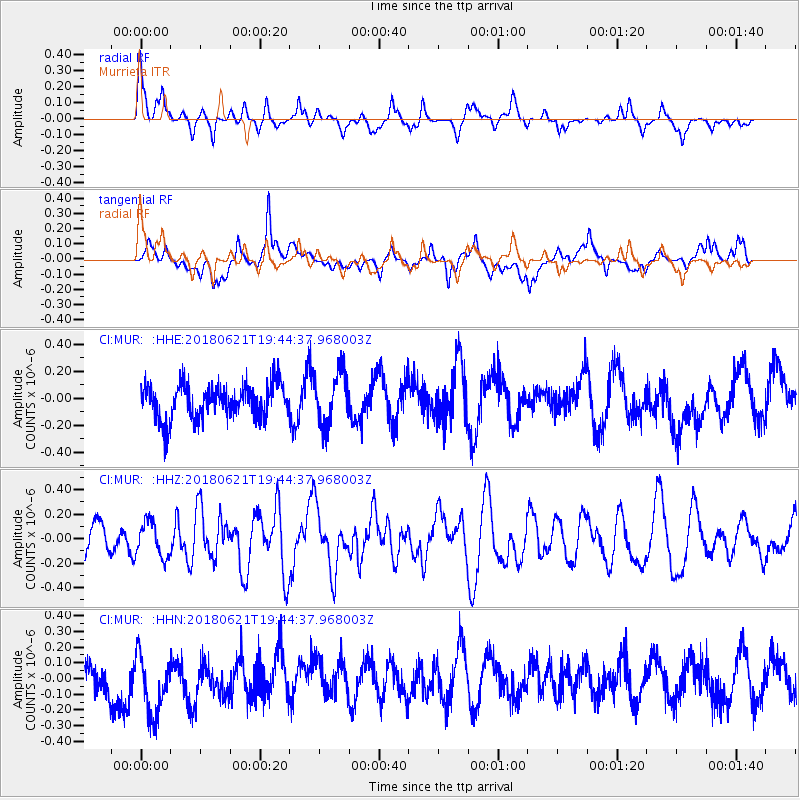
MUR Murrieta - Earthquake Result Viewer
*The percent match for this event was below the threshold and hence no stack was calculated.
| Earthquake location: |
Tonga Islands Region |
| Earthquake latitude/longitude: |
-22.5/-174.9 |
| Earthquake time(UTC): |
2018/06/21 (172) 19:33:08 GMT |
| Earthquake Depth: |
4.8 km |
| Earthquake Magnitude: |
5.4 mb |
| Earthquake Catalog/Contributor: |
NEIC PDE/us |
|
| Network: |
CI Caltech Regional Seismic Network |
| Station: |
MUR Murrieta |
| Lat/Lon: |
33.60 N/117.20 W |
| Elevation: |
562 m |
|
| Distance: |
78.3 deg |
| Az: |
46.095 deg |
| Baz: |
232.947 deg |
| Ray Param: |
$rayparam |
*The percent match for this event was below the threshold and hence was not used in the summary stack. |
|
| Radial Match: |
56.13274 % |
| Radial Bump: |
354 |
| Transverse Match: |
48.101532 % |
| Transverse Bump: |
400 |
| SOD ConfigId: |
13570011 |
| Insert Time: |
2019-04-30 10:22:36.484 +0000 |
| GWidth: |
2.5 |
| Max Bumps: |
400 |
| Tol: |
0.001 |
|
Signal To Noise
| Channel | StoN | STA | LTA |
| CI:MUR: :HHZ:20180621T19:44:37.968003Z | 1.1845055 | 1.4239484E-7 | 1.202146E-7 |
| CI:MUR: :HHN:20180621T19:44:37.968003Z | 1.2523732 | 2.3847318E-7 | 1.9041703E-7 |
| CI:MUR: :HHE:20180621T19:44:37.968003Z | 1.5345451 | 1.9309729E-7 | 1.2583358E-7 |
| Arrivals |
| Ps | |
| PpPs | |
| PsPs/PpSs | |


