You are here: Home > Network List > TA - USArray Transportable Network (new EarthScope stations) Stations List
> Station D17A Six Diamond Ranch, Ranyesford, MT, USA > Earthquake Result Viewer
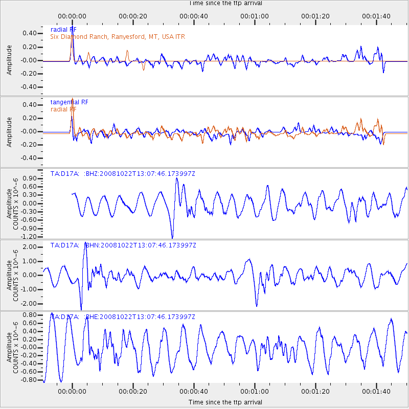
D17A Six Diamond Ranch, Ranyesford, MT, USA - Earthquake Result Viewer
*The percent match for this event was below the threshold and hence no stack was calculated.
| Earthquake location: |
Tonga Islands |
| Earthquake latitude/longitude: |
-18.4/-175.4 |
| Earthquake time(UTC): |
2008/10/22 (296) 12:55:57 GMT |
| Earthquake Depth: |
233 km |
| Earthquake Magnitude: |
5.9 MB, 6.4 MW, 6.3 MW |
| Earthquake Catalog/Contributor: |
WHDF/NEIC |
|
| Network: |
TA USArray Transportable Network (new EarthScope stations) |
| Station: |
D17A Six Diamond Ranch, Ranyesford, MT, USA |
| Lat/Lon: |
47.15 N/110.69 W |
| Elevation: |
1535 m |
|
| Distance: |
87.3 deg |
| Az: |
38.138 deg |
| Baz: |
239.215 deg |
| Ray Param: |
$rayparam |
*The percent match for this event was below the threshold and hence was not used in the summary stack. |
|
| Radial Match: |
71.81389 % |
| Radial Bump: |
400 |
| Transverse Match: |
54.899704 % |
| Transverse Bump: |
388 |
| SOD ConfigId: |
2556 |
| Insert Time: |
2010-03-06 11:53:04.764 +0000 |
| GWidth: |
2.5 |
| Max Bumps: |
400 |
| Tol: |
0.001 |
|
Signal To Noise
| Channel | StoN | STA | LTA |
| TA:D17A: :BHN:20081022T13:07:46.173997Z | 3.5252378 | 1.1825755E-6 | 3.354598E-7 |
| TA:D17A: :BHE:20081022T13:07:46.173997Z | 1.2409465 | 4.5598807E-7 | 3.6745183E-7 |
| TA:D17A: :BHZ:20081022T13:07:46.173997Z | 2.3096461 | 5.960924E-7 | 2.5808816E-7 |
| Arrivals |
| Ps | |
| PpPs | |
| PsPs/PpSs | |


