You are here: Home > Network List > NN - Western Great Basin/Eastern Sierra Nevada Stations List
> Station CMK6 Chalk Mountain, Churchill County, NV, USA > Earthquake Result Viewer
CMK6 Chalk Mountain, Churchill County, NV, USA - Earthquake Result Viewer
| Earthquake location: |
Tonga Islands Region |
| Earthquake latitude/longitude: |
-22.5/-174.9 |
| Earthquake time(UTC): |
2018/06/21 (172) 19:33:08 GMT |
| Earthquake Depth: |
4.8 km |
| Earthquake Magnitude: |
5.4 mb |
| Earthquake Catalog/Contributor: |
NEIC PDE/us |
|
| Network: |
NN Western Great Basin/Eastern Sierra Nevada |
| Station: |
CMK6 Chalk Mountain, Churchill County, NV, USA |
| Lat/Lon: |
39.31 N/118.12 W |
| Elevation: |
1332 m |
|
| Distance: |
81.2 deg |
| Az: |
41.055 deg |
| Baz: |
231.505 deg |
| Ray Param: |
0.04773556 |
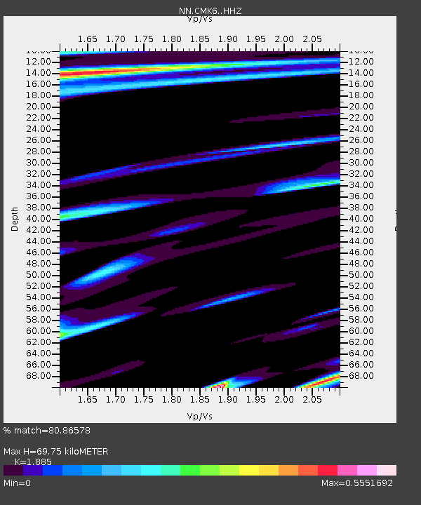
| Estimated Moho Depth: |
69.75 km |
| Estimated Crust Vp/Vs: |
1.88 |
| Assumed Crust Vp: |
6.279 km/s |
| Estimated Crust Vs: |
3.331 km/s |
| Estimated Crust Poisson's Ratio: |
0.30 |
|
| Radial Match: |
80.86578 % |
| Radial Bump: |
400 |
| Transverse Match: |
55.991142 % |
| Transverse Bump: |
400 |
| SOD ConfigId: |
13570011 |
| Insert Time: |
2019-04-30 10:23:48.116 +0000 |
| GWidth: |
2.5 |
| Max Bumps: |
400 |
| Tol: |
0.001 |
|

Signal To Noise
| Channel | StoN | STA | LTA |
| NN:CMK6: :HHZ:20180621T19:44:53.694993Z | 1.4151793 | 5.157408E-8 | 3.6443495E-8 |
| NN:CMK6: :HHN:20180621T19:44:53.694993Z | 1.099171 | 5.04988E-8 | 4.594262E-8 |
| NN:CMK6: :HHE:20180621T19:44:53.694993Z | 0.94973147 | 4.5505217E-8 | 4.7913773E-8 |
| Arrivals |
| Ps | 10 SECOND |
| PpPs | 31 SECOND |
| PsPs/PpSs | 41 SECOND |


