You are here: Home > Network List > TA - USArray Transportable Network (new EarthScope stations) Stations List
> Station N15K Kwethluk River, AK, USA > Earthquake Result Viewer
N15K Kwethluk River, AK, USA - Earthquake Result Viewer
| Earthquake location: |
Tonga Islands Region |
| Earthquake latitude/longitude: |
-22.5/-174.9 |
| Earthquake time(UTC): |
2018/06/21 (172) 19:33:08 GMT |
| Earthquake Depth: |
4.8 km |
| Earthquake Magnitude: |
5.4 mb |
| Earthquake Catalog/Contributor: |
NEIC PDE/us |
|
| Network: |
TA USArray Transportable Network (new EarthScope stations) |
| Station: |
N15K Kwethluk River, AK, USA |
| Lat/Lon: |
60.17 N/160.09 W |
| Elevation: |
449 m |
|
| Distance: |
83.3 deg |
| Az: |
7.398 deg |
| Baz: |
193.775 deg |
| Ray Param: |
0.046298873 |
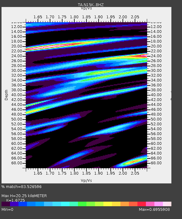
| Estimated Moho Depth: |
20.25 km |
| Estimated Crust Vp/Vs: |
1.67 |
| Assumed Crust Vp: |
6.182 km/s |
| Estimated Crust Vs: |
3.696 km/s |
| Estimated Crust Poisson's Ratio: |
0.22 |
|
| Radial Match: |
83.526596 % |
| Radial Bump: |
400 |
| Transverse Match: |
66.80458 % |
| Transverse Bump: |
400 |
| SOD ConfigId: |
13570011 |
| Insert Time: |
2019-04-30 10:25:21.150 +0000 |
| GWidth: |
2.5 |
| Max Bumps: |
400 |
| Tol: |
0.001 |
|

Signal To Noise
| Channel | StoN | STA | LTA |
| TA:N15K: :BHZ:20180621T19:45:04.699998Z | 1.1443413 | 9.6944476E-8 | 8.4716405E-8 |
| TA:N15K: :BHN:20180621T19:45:04.699998Z | 0.8779166 | 6.4369374E-8 | 7.33206E-8 |
| TA:N15K: :BHE:20180621T19:45:04.699998Z | 1.4910388 | 1.070655E-7 | 7.180598E-8 |
| Arrivals |
| Ps | 2.3 SECOND |
| PpPs | 8.5 SECOND |
| PsPs/PpSs | 11 SECOND |


