You are here: Home > Network List > TA - USArray Transportable Network (new EarthScope stations) Stations List
> Station O17K Koliganek, Bristol Bay, AK, USA > Earthquake Result Viewer
O17K Koliganek, Bristol Bay, AK, USA - Earthquake Result Viewer
| Earthquake location: |
Tonga Islands Region |
| Earthquake latitude/longitude: |
-22.5/-174.9 |
| Earthquake time(UTC): |
2018/06/21 (172) 19:33:08 GMT |
| Earthquake Depth: |
4.8 km |
| Earthquake Magnitude: |
5.4 mb |
| Earthquake Catalog/Contributor: |
NEIC PDE/us |
|
| Network: |
TA USArray Transportable Network (new EarthScope stations) |
| Station: |
O17K Koliganek, Bristol Bay, AK, USA |
| Lat/Lon: |
59.77 N/157.09 W |
| Elevation: |
156 m |
|
| Distance: |
83.3 deg |
| Az: |
8.968 deg |
| Baz: |
196.549 deg |
| Ray Param: |
0.04629061 |
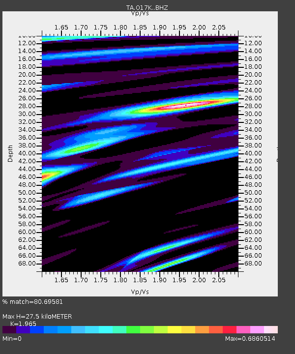
| Estimated Moho Depth: |
27.5 km |
| Estimated Crust Vp/Vs: |
1.97 |
| Assumed Crust Vp: |
6.276 km/s |
| Estimated Crust Vs: |
3.194 km/s |
| Estimated Crust Poisson's Ratio: |
0.33 |
|
| Radial Match: |
80.69581 % |
| Radial Bump: |
400 |
| Transverse Match: |
66.302574 % |
| Transverse Bump: |
400 |
| SOD ConfigId: |
13570011 |
| Insert Time: |
2019-04-30 10:25:26.760 +0000 |
| GWidth: |
2.5 |
| Max Bumps: |
400 |
| Tol: |
0.001 |
|
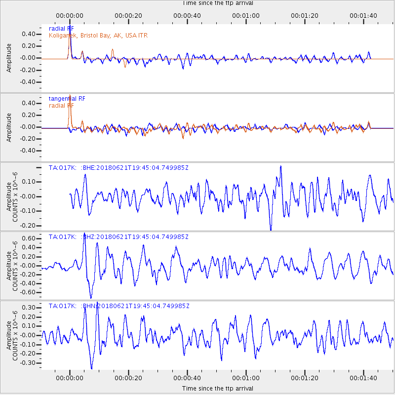
Signal To Noise
| Channel | StoN | STA | LTA |
| TA:O17K: :BHZ:20180621T19:45:04.749985Z | 2.4729009 | 1.7359395E-7 | 7.019851E-8 |
| TA:O17K: :BHN:20180621T19:45:04.749985Z | 1.2445335 | 5.5461342E-8 | 4.4563958E-8 |
| TA:O17K: :BHE:20180621T19:45:04.749985Z | 0.9908214 | 5.112774E-8 | 5.1601365E-8 |
| Arrivals |
| Ps | 4.3 SECOND |
| PpPs | 13 SECOND |
| PsPs/PpSs | 17 SECOND |


